Pāvugada geodata
Pāvugada (Karnataka) is a populated place; located in India in Asia/Kolkata (GMT+5.5) time zone. With population of 32,063 people, there are 1354 cities with bigger population in this country. Compared to other cities in India, 83.1% of cities are located further ↑North; 60.2% of cities are located further →East and 90.2% of cities have lower elevation than Pāvugada. Note1


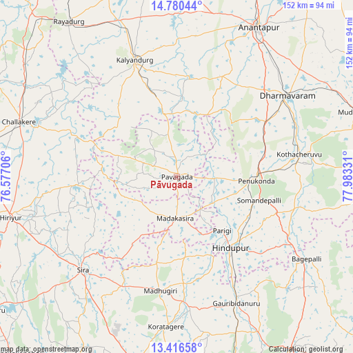
Pāvugada GPS coordinates[2]
14° 5' 58.308" North, 77° 16' 48.648" East
| Map corner | latitude | longitude |
|---|---|---|
| Upper-left | 14.78044°, | 76.57706° |
| Center: | 14.09953°, | 77.28018° |
| Lower-right: | 13.41658°, | 77.98331° |
| Map W x H: | 151.6×151.6 km | = 94.2×94.2mi |
| max Lat: | 34.9274° ⇑83.1% North |
| Pāvugada: | 14.09953° |
| min Lat: | ⇓16.9% South 8.09008° |
| min Long | Pāvugada | max Long |
| 68.82655° | 77.28018° | 96.81° |
| W 39.8%⇐ | ⇒60.2% E |
Elevation
Elevation of Pāvugada is 640 m = 2100 ft, and this is 344.4 m = 1130 ft above average elevation for this country.
| Max E: |
3681 m = 12077 ft | 9.8% |
| Pāvugada | 640 m 2100 ft | |
| Avg. | 295.6 m = 970 ft | |
Min E: |
1 m = 3 ft | 90.2% |
See also: India elevation on elevation.city.
Geographical zone
Pāvugada is located in North Torrid zone (between Equator and Tropic of Cancer). Distance of this Northern Tropic circle is 1038.2 km =645.1 mi to North.| Distance of | km | miles | from Pāvugada |
|---|---|---|---|
| North Pole | 8439.3 | 5243.9 | to North |
| Arctic Circle | 5833.5 | 3624.8 | to North |
| Tropic Cancer | 1038.2 | 645.1 | to North |
| Equator | 1567.7 | 974.1 | to South |


Nearby cities:
15 places around Pāvugada: (largest is in red/bold)
• Bāgepalli
65.9 km =40.9 mi,  122°
122°
• Challakere
72 km =44.7 mi,  289°
289°
• Dharmavaram
59 km =36.7 mi,  53°
53°
• Gorantla
54.6 km =33.9 mi,  103°
103°
• Goribidnūr
60.1 km =37.3 mi,  154°
154°
• Gudibanda
66.1 km =41.1 mi,  136°
136°
• Hindupur
37.8 km =23.5 mi, 142°
• Hosakote
23 km =14.3 mi,  328°
328°
• Kalyandurg
53 km =32.9 mi,  339°
339°
• Kodigenahalli
43.6 km =27.1 mi,  164°
164°
• Koratagere
64.4 km =40 mi,  184°
184°
• Maddagiri
49.4 km =30.7 mi,  188°
188°
• Penukonda
34 km =21.1 mi,  93°
93°
• Puttaparthi
57.8 km =35.9 mi,  82°
82°
• Sīra
56.8 km =35.3 mi,  225°
225°
Sources, notices
• [Note1] Compared only with cities in India existing in our database
• [Src1] Map data: © OpenStreetMap contributors (CC-BY-SA)
• [Src2] Other city data from geonames.org with taken over terms of usage.
• [Src3] Geographical zone / Annual Mean Temperature by Robert A. Rohde @ Wikipedia
