Anantapur geodata
Anantapur (Andhra Pradesh) is a populated place; located in India in Asia/Kolkata (GMT+5.5) time zone. With population of 240,442 people, there are 179 cities with bigger population in this country. Compared to other cities in India, 82.1% of cities are located further ↑North; 56% of cities are located further →East and 72.1% of cities have lower elevation than Anantapur. Note1


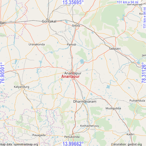
Anantapur GPS coordinates[2]
14° 40' 40.224" North, 77° 36' 29.268" East
| Map corner | latitude | longitude |
|---|---|---|
| Upper-left | 15.35695°, | 76.90501° |
| Center: | 14.67784°, | 77.60813° |
| Lower-right: | 13.99662°, | 78.31126° |
| Map W x H: | 151.3×151.3 km | = 94×94mi |
| max Lat: | 34.9274° ⇑82.1% North |
| Anantapur: | 14.67784° |
| min Lat: | ⇓17.9% South 8.09008° |
| min Long | Anantapur | max Long |
| 68.82655° | 77.60813° | 96.81° |
| W 44%⇐ | ⇒56% E |
Elevation
Elevation of Anantapur is 350 m = 1148 ft, and this is 54.4 m = 178 ft above average elevation for this country.
| Max E: |
3681 m = 12077 ft | 27.9% |
| Anantapur | 350 m 1148 ft | |
| Avg. | 295.6 m = 970 ft | |
Min E: |
1 m = 3 ft | 72.1% |
See also: Anantapur elevation on elevation.city.
Geographical zone
Anantapur is located in North Torrid zone (between Equator and Tropic of Cancer). Distance of this Northern Tropic circle is 973.9 km =605.2 mi to North.| Distance of | km | miles | from Anantapur |
|---|---|---|---|
| North Pole | 8375 | 5204 | to North |
| Arctic Circle | 5769.2 | 3584.8 | to North |
| Tropic Cancer | 973.9 | 605.2 | to North |
| Equator | 1632 | 1014.1 | to South |


Nearby cities:
15 places around Anantapur: (largest is in red/bold)
• Dharmavaram
31.7 km =19.7 mi,  157°
157°
• Dhone
84.6 km =52.6 mi,  19°
19°
• Gorantla
79.1 km =49.2 mi,  167°
167°
• Guntakal Junction
60.9 km =37.8 mi,  334°
334°
• Hosakote
65.1 km =40.5 mi,  226°
226°
• Jammalamadugu
85.4 km =53.1 mi,  77°
77°
• Kalyandurg
56.1 km =34.9 mi,  254°
254°
• Penukonda
66.2 km =41.1 mi,  181°
181°
• Pulivendla
72.3 km =44.9 mi,  113°
113°
• Puttaparthi
61.1 km =38 mi, 158°
• Pāvugada
73.4 km =45.6 mi,  208°
208°
• Rāmāpuram
73.3 km =45.5 mi, 22°
• Rāyadrug
81.3 km =50.5 mi,  271°
271°
• Tādpatri
50.3 km =31.3 mi,  59°
59°
• Uravakonda
48.1 km =29.9 mi,  307°
307°
Sources, notices
• [Note1] Compared only with cities in India existing in our database
• [Src1] Map data: © OpenStreetMap contributors (CC-BY-SA)
• [Src2] Other city data from geonames.org with taken over terms of usage.
• [Src3] Geographical zone / Annual Mean Temperature by Robert A. Rohde @ Wikipedia
