Tādpatri geodata
Tādpatri (Andhra Pradesh) is a populated place; located in India in Asia/Kolkata (GMT+5.5) time zone. With population of 93,044 people, there are 480 cities with bigger population in this country. Compared to other cities in India, 81.8% of cities are located further ↑North; 51.3% of cities are located further →East and 58.1% of cities have lower elevation than Tādpatri. Note1


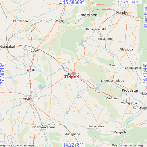
Tādpatri GPS coordinates[2]
14° 54' 29.952" North, 78° 0' 37.116" East
| Map corner | latitude | longitude |
|---|---|---|
| Upper-left | 15.58669°, | 77.30719° |
| Center: | 14.90832°, | 78.01031° |
| Lower-right: | 14.22781°, | 78.71344° |
| Map W x H: | 151.1×151.1 km | = 93.9×93.9mi |
| max Lat: | 34.9274° ⇑81.8% North |
| Tādpatri: | 14.90832° |
| min Lat: | ⇓18.2% South 8.09008° |
| min Long | Tādpatri | max Long |
| 68.82655° | 78.01031° | 96.81° |
| W 48.7%⇐ | ⇒51.3% E |
Elevation
Elevation of Tādpatri is 240 m = 787 ft, and this is 55.6 m = 182 ft below average elevation for this country.
| Max E: |
3681 m = 12077 ft | 41.9% |
| Avg. | 295.6 m = 970 ft | |
| Tādpatri | 240 m = 787 ft | |
Min E: |
1 m = 3 ft | 58.1% |
See also: Tādpatri elevation on elevation.city.
Geographical zone
Tādpatri is located in North Torrid zone (between Equator and Tropic of Cancer). Distance of this Northern Tropic circle is 948.3 km =589.2 mi to North.| Distance of | km | miles | from Tādpatri |
|---|---|---|---|
| North Pole | 8349.4 | 5188.1 | to North |
| Arctic Circle | 5743.5 | 3568.8 | to North |
| Tropic Cancer | 948.3 | 589.2 | to North |
| Equator | 1657.6 | 1030 | to South |


Nearby cities:
15 places around Tādpatri: (largest is in red/bold)
• Anantapur
50.3 km =31.3 mi,  239°
239°
• Banganapalle
51.1 km =31.8 mi,  27°
27°
• Betamcherla
62.2 km =38.6 mi,  13°
13°
• Dharmavaram
63.2 km =39.3 mi,  209°
209°
• Dhone
56.1 km =34.9 mi,  344°
344°
• Erraguntla
64.3 km =40 mi,  117°
117°
• Guntakal Junction
75.5 km =46.9 mi,  292°
292°
• Jammalamadugu
40.6 km =25.2 mi,  99°
99°
• Kāmalāpuram
78.8 km =49 mi, 115°
• Nandyāl
81.2 km =50.5 mi,  38°
38°
• Proddatūr
60.4 km =37.5 mi,  106°
106°
• Pulivendla
58.9 km =36.6 mi,  156°
156°
• Puttaparthi
85.3 km =53 mi,  194°
194°
• Rāmāpuram
44.9 km =27.9 mi, 339°
• Uravakonda
81.2 km =50.5 mi,  272°
272°
Sources, notices
• [Note1] Compared only with cities in India existing in our database
• [Src1] Map data: © OpenStreetMap contributors (CC-BY-SA)
• [Src2] Other city data from geonames.org with taken over terms of usage.
• [Src3] Geographical zone / Annual Mean Temperature by Robert A. Rohde @ Wikipedia
