Dāsna geodata
Dāsna (Uttar Pradesh) is a populated place; located in India in Asia/Kolkata (GMT+5.5) time zone. With population of 27,926 people, there are 1541 cities with bigger population in this country. Compared to other cities in India, 87.7% of cities are located further ↓South; 57% of cities are located further →East and 53.8% of cities have lower elevation than Dāsna. Note1


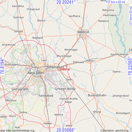
Dāsna GPS coordinates[2]
28° 40' 38.496" North, 77° 31' 21.072" East
| Map corner | latitude | longitude |
|---|---|---|
| Upper-left | 29.29241°, | 76.8194° |
| Center: | 28.67736°, | 77.52252° |
| Lower-right: | 28.05868°, | 78.22565° |
| Map W x H: | 137.2×137.2 km | = 85.3×85.3mi |
| max Lat: | 34.9274° ⇑12.3% North |
| Dāsna: | 28.67736° |
| min Lat: | ⇓87.7% South 8.09008° |
| min Long | Dāsna | max Long |
| 68.82655° | 77.52252° | 96.81° |
| W 43%⇐ | ⇒57% E |
Elevation
Elevation of Dāsna is 221 m = 725 ft, and this is 74.6 m = 245 ft below average elevation for this country.
| Max E: |
3681 m = 12077 ft | 46.2% |
| Avg. | 295.6 m = 970 ft | |
| Dāsna | 221 m = 725 ft | |
Min E: |
1 m = 3 ft | 53.8% |
See also: India elevation on elevation.city.
Geographical zone
Dāsna is located in North temperate zone (between Tropic of Cancer and the Arctic Circle). Distance of this Northern Tropic circle is 582.7 km =362.1 mi to South.| Distance of | km | miles | from Dāsna |
|---|---|---|---|
| North Pole | 6818.4 | 4236.8 | to North |
| Arctic Circle | 4212.6 | 2617.6 | to North |
| Tropic Cancer | 582.7 | 362.1 | to South |
| Equator | 3188.6 | 1981.3 | to South |


Nearby cities:
15 places around Dāsna: (largest is in red/bold)
• Delhi
28.5 km =17.7 mi,  264°
264°
• Dādri
14.2 km =8.8 mi,  167°
167°
• Farīdnagar
14.6 km =9.1 mi,  45°
45°
• Ghāziābād
8.2 km =5.1 mi, 260°
• Greater Noida
20.2 km =12.6 mi,  176°
176°
• Gulāothi
28.2 km =17.5 mi,  110°
110°
• Hāpur
25.8 km =16 mi,  76°
76°
• Kharkhauda
27.7 km =17.2 mi, 50°
• Loni
24.1 km =15 mi,  289°
289°
• Murādnagar
11.7 km =7.3 mi,  348°
348°
• New Delhi
29.4 km =18.3 mi, 260°
• Niwāri
22.2 km =13.8 mi,  3°
3°
• Noida
21.7 km =13.5 mi,  240°
240°
• Pilkhua
13.6 km =8.5 mi,  73°
73°
• Sector
22.5 km =14 mi, 238°
Sources, notices
• [Note1] Compared only with cities in India existing in our database
• [Src1] Map data: © OpenStreetMap contributors (CC-BY-SA)
• [Src2] Other city data from geonames.org with taken over terms of usage.
• [Src3] Geographical zone / Annual Mean Temperature by Robert A. Rohde @ Wikipedia
