Murādnagar geodata
Murādnagar (Uttar Pradesh) is a populated place; located in India in Asia/Kolkata (GMT+5.5) time zone. With population of 89,482 people, there are 498 cities with bigger population in this country. Compared to other cities in India, 88.2% of cities are located further ↓South; 57.3% of cities are located further →East and 54% of cities have lower elevation than Murādnagar. Note1


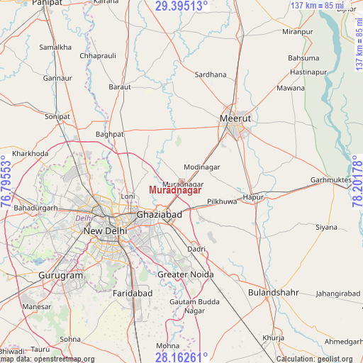
Murādnagar GPS coordinates[2]
28° 46' 50.484" North, 77° 29' 55.14" East
| Map corner | latitude | longitude |
|---|---|---|
| Upper-left | 29.39513°, | 76.79553° |
| Center: | 28.78069°, | 77.49865° |
| Lower-right: | 28.16261°, | 78.20178° |
| Map W x H: | 137×137 km | = 85.1×85.1mi |
| max Lat: | 34.9274° ⇑11.8% North |
| Murādnagar: | 28.78069° |
| min Lat: | ⇓88.2% South 8.09008° |
| min Long | Murādnagar | max Long |
| 68.82655° | 77.49865° | 96.81° |
| W 42.7%⇐ | ⇒57.3% E |
Elevation
Elevation of Murādnagar is 222 m = 728 ft, and this is 73.6 m = 241 ft below average elevation for this country.
| Max E: |
3681 m = 12077 ft | 46% |
| Avg. | 295.6 m = 970 ft | |
| Murādnagar | 222 m = 728 ft | |
Min E: |
1 m = 3 ft | 54% |
See also: Murādnagar elevation on elevation.city.
Geographical zone
Murādnagar is located in North temperate zone (between Tropic of Cancer and the Arctic Circle). Distance of this Northern Tropic circle is 594.2 km =369.2 mi to South.| Distance of | km | miles | from Murādnagar |
|---|---|---|---|
| North Pole | 6806.9 | 4229.6 | to North |
| Arctic Circle | 4201.1 | 2610.4 | to North |
| Tropic Cancer | 594.2 | 369.2 | to South |
| Equator | 3200.1 | 1988.4 | to South |


Nearby cities:
15 places around Murādnagar: (largest is in red/bold)
• Delhi
29.7 km =18.5 mi,  241°
241°
• Dādri
25.9 km =16.1 mi,  167°
167°
• Dāsna
11.7 km =7.3 mi, 168°
• Farīdnagar
12.8 km =8 mi,  95°
95°
• Ghāziābād
14.1 km =8.8 mi,  204°
204°
• Hāpur
28.1 km =17.5 mi, 101°
• Kharkhauda
24.5 km =15.2 mi,  75°
75°
• Khekra
22.9 km =14.2 mi,  294°
294°
• Loni
20.6 km =12.8 mi,  260°
260°
• Meerut
30 km =18.6 mi,  42°
42°
• New Delhi
31.2 km =19.4 mi, 238°
• Niwāri
11.3 km =7 mi,  19°
19°
• Noida
27.7 km =17.2 mi,  216°
216°
• Pilkhua
17.1 km =10.6 mi,  116°
116°
• Sector
28.8 km =17.9 mi, 215°
Sources, notices
• [Note1] Compared only with cities in India existing in our database
• [Src1] Map data: © OpenStreetMap contributors (CC-BY-SA)
• [Src2] Other city data from geonames.org with taken over terms of usage.
• [Src3] Geographical zone / Annual Mean Temperature by Robert A. Rohde @ Wikipedia
