Rājgarh geodata
Rājgarh (Himachal Pradesh) is a populated place; located in India in Asia/Kolkata (GMT+5.5) time zone. With population of 2,865 people, there are 3417 cities with bigger population in this country. Compared to other cities in India, 95.4% of cities are located further ↓South; 59.8% of cities are located further →East and 97.8% of cities have lower elevation than Rājgarh. Note1


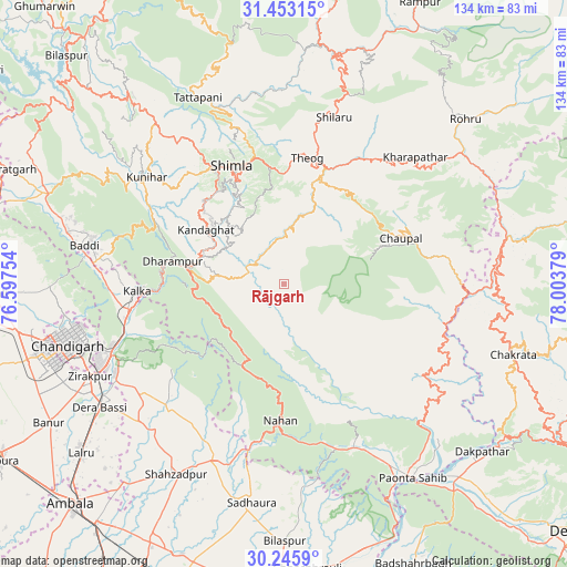
Rājgarh GPS coordinates[2]
30° 51' 5.112" North, 77° 18' 2.376" East
| Map corner | latitude | longitude |
|---|---|---|
| Upper-left | 31.45315°, | 76.59754° |
| Center: | 30.85142°, | 77.30066° |
| Lower-right: | 30.2459°, | 78.00379° |
| Map W x H: | 134.2×134.2 km | = 83.4×83.4mi |
| max Lat: | 34.9274° ⇑4.6% North |
| Rājgarh: | 30.85142° |
| min Lat: | ⇓95.4% South 8.09008° |
| min Long | Rājgarh | max Long |
| 68.82655° | 77.30066° | 96.81° |
| W 40.2%⇐ | ⇒59.8% E |
Elevation
Elevation of Rājgarh is 1524 m = 5000 ft, and this is 1228.4 m = 4030 ft above average elevation for this country.
| Max E: |
3681 m = 12077 ft | 2.2% |
| Rājgarh | 1524 m 5000 ft | |
| Avg. | 295.6 m = 970 ft | |
Min E: |
1 m = 3 ft | 97.8% |
See also: India elevation on elevation.city.
Geographical zone
Rājgarh is located in North temperate zone (between Tropic of Cancer and the Arctic Circle). Distance of this Northern Tropic circle is 824.4 km =512.3 mi to South.| Distance of | km | miles | from Rājgarh |
|---|---|---|---|
| North Pole | 6576.7 | 4086.6 | to North |
| Arctic Circle | 3970.8 | 2467.3 | to North |
| Tropic Cancer | 824.4 | 512.3 | to South |
| Equator | 3430.4 | 2131.6 | to South |


Nearby cities:
15 places around Rājgarh: (largest is in red/bold)
• Chaupāl
29.4 km =18.3 mi,  68°
68°
• Dagshai
24 km =14.9 mi,  278°
278°
• Jubbal
44 km =27.3 mi,  49°
49°
• Jutogh
32.7 km =20.3 mi,  327°
327°
• Kasauli
32.4 km =20.1 mi, 279°
• Kotkhai
37.3 km =23.2 mi,  37°
37°
• Kālka
34.4 km =21.4 mi,  267°
267°
• Narāyangarh
44.7 km =27.8 mi,  201°
201°
• Nāhan
32.4 km =20.1 mi,  181°
181°
• Parwanoo
32.4 km =20.1 mi, 267°
• Pinjaur
37 km =23 mi,  260°
260°
• Sabāthu
32.5 km =20.2 mi,  294°
294°
• Shimla
30.9 km =19.2 mi,  335°
335°
• Solan
19.4 km =12.1 mi, 289°
• Theog
30.5 km =19 mi,  10°
10°
Sources, notices
• [Note1] Compared only with cities in India existing in our database
• [Src1] Map data: © OpenStreetMap contributors (CC-BY-SA)
• [Src2] Other city data from geonames.org with taken over terms of usage.
• [Src3] Geographical zone / Annual Mean Temperature by Robert A. Rohde @ Wikipedia
