Hoshangābād geodata
Hoshangābād (Madhya Pradesh) is a populated place; located in India in Asia/Kolkata (GMT+5.5) time zone. With population of 109,358 people, there are 406 cities with bigger population in this country. Compared to other cities in India, 50.4% of cities are located further ↑North; 54.7% of cities are located further →East and 67% of cities have lower elevation than Hoshangābād. Note1


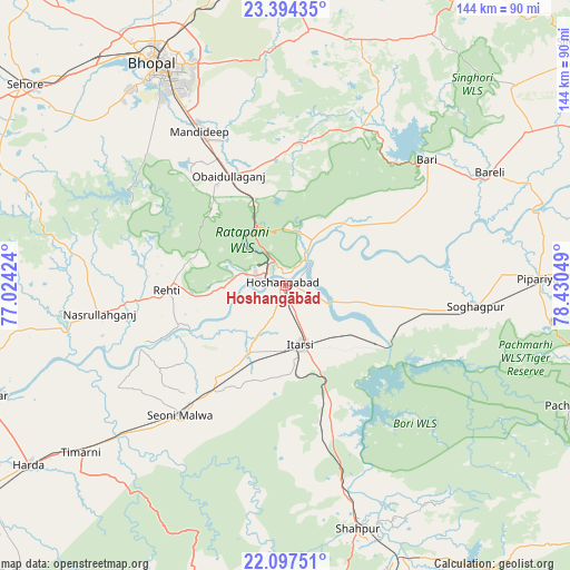
Hoshangābād GPS coordinates[2]
22° 44' 50.892" North, 77° 43' 38.496" East
| Map corner | latitude | longitude |
|---|---|---|
| Upper-left | 23.39435°, | 77.02424° |
| Center: | 22.74747°, | 77.72736° |
| Lower-right: | 22.09751°, | 78.43049° |
| Map W x H: | 144.2×144.2 km | = 89.6×89.6mi |
| max Lat: | 34.9274° ⇑50.4% North |
| Hoshangābād: | 22.74747° |
| min Lat: | ⇓49.6% South 8.09008° |
| min Long | Hoshangābād | max Long |
| 68.82655° | 77.72736° | 96.81° |
| W 45.3%⇐ | ⇒54.7% E |
Elevation
Elevation of Hoshangābād is 301 m = 988 ft, and this is 5.4 m = 18 ft above average elevation for this country.
| Max E: |
3681 m = 12077 ft | 33% |
| Hoshangābād | 301 m 988 ft | |
| Avg. | 295.6 m = 970 ft | |
Min E: |
1 m = 3 ft | 67% |
See also: Hoshangābād elevation on elevation.city.
Geographical zone
Hoshangābād is located in North Torrid zone (between Equator and Tropic of Cancer). Distance of this Northern Tropic circle is 76.6 km =47.6 mi to North.| Distance of | km | miles | from Hoshangābād |
|---|---|---|---|
| North Pole | 7477.8 | 4646.5 | to North |
| Arctic Circle | 4871.9 | 3027.3 | to North |
| Tropic Cancer | 76.6 | 47.6 | to North |
| Equator | 2529.3 | 1571.6 | to South |


Nearby cities:
15 places around Hoshangābād: (largest is in red/bold)
• Bhopal
65.4 km =40.6 mi,  329°
329°
• Bābai
21.9 km =13.6 mi,  103°
103°
• Harda Khās
78.9 km =49 mi,  235°
235°
• Ichhāwar
79.1 km =49.2 mi,  293°
293°
• Itārsi
15.2 km =9.4 mi,  166°
166°
• Mandideep
42.1 km =26.2 mi, 331°
• Nasrullāhganj
47.4 km =29.5 mi,  261°
261°
• Pachmarhi
78.8 km =49 mi,  113°
113°
• Raisen
65 km =40.4 mi,  4°
4°
• Rehti
30.1 km =18.7 mi,  267°
267°
• Seoni Mālwa
42.5 km =26.4 mi,  219°
219°
• Shāhpur
64.1 km =39.8 mi,  163°
163°
• Sohāgpur
48.3 km =30 mi, 96°
• Sultānpur
48.3 km =30 mi,  25°
25°
• Sānchi
82.2 km =51.1 mi, 0°
Sources, notices
• [Note1] Compared only with cities in India existing in our database
• [Src1] Map data: © OpenStreetMap contributors (CC-BY-SA)
• [Src2] Other city data from geonames.org with taken over terms of usage.
• [Src3] Geographical zone / Annual Mean Temperature by Robert A. Rohde @ Wikipedia
