Sānchi geodata
Sānchi (Madhya Pradesh) is a populated place; located in India in Asia/Kolkata (GMT+5.5) time zone. With population of 7,302 people, there are 3191 cities with bigger population in this country. Compared to other cities in India, 54.7% of cities are located further ↓South; 54.5% of cities are located further →East and 77.8% of cities have lower elevation than Sānchi. Note1


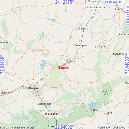
Sānchi GPS coordinates[2]
23° 29' 11.256" North, 77° 44' 16.08" East
| Map corner | latitude | longitude |
|---|---|---|
| Upper-left | 24.12975°, | 77.03468° |
| Center: | 23.48646°, | 77.7378° |
| Lower-right: | 22.84002°, | 78.44093° |
| Map W x H: | 143.4×143.4 km | = 89.1×89.1mi |
| max Lat: | 34.9274° ⇑45.3% North |
| Sānchi: | 23.48646° |
| min Lat: | ⇓54.7% South 8.09008° |
| min Long | Sānchi | max Long |
| 68.82655° | 77.7378° | 96.81° |
| W 45.5%⇐ | ⇒54.5% E |
Elevation
Elevation of Sānchi is 427 m = 1401 ft, and this is 131.4 m = 431 ft above average elevation for this country.
| Max E: |
3681 m = 12077 ft | 22.2% |
| Sānchi | 427 m 1401 ft | |
| Avg. | 295.6 m = 970 ft | |
Min E: |
1 m = 3 ft | 77.8% |
See also: India elevation on elevation.city.
Geographical zone
Sānchi is located in North temperate zone (between Tropic of Cancer and the Arctic Circle). Distance of this Northern Tropic circle is 5.5 km =3.4 mi to South.| Distance of | km | miles | from Sānchi |
|---|---|---|---|
| North Pole | 7395.6 | 4595.4 | to North |
| Arctic Circle | 4789.7 | 2976.2 | to North |
| Tropic Cancer | 5.5 | 3.4 | to South |
| Equator | 2611.4 | 1622.6 | to South |


Nearby cities:
15 places around Sānchi: (largest is in red/bold)
• Begamganj
62.7 km =39 mi,  78°
78°
• Berasia
34.9 km =21.7 mi,  297°
297°
• Bhopal
42.8 km =26.6 mi,  232°
232°
• Bāsoda
45.4 km =28.2 mi,  26°
26°
• Chandpura
60.6 km =37.7 mi,  312°
312°
• Garha Brahman
57.5 km =35.7 mi,  317°
317°
• Khata Khedi
62.6 km =38.9 mi, 313°
• Leteri
72 km =44.7 mi,  332°
332°
• Mandideep
49.6 km =30.8 mi,  204°
204°
• Narsinghgarh
70.1 km =43.6 mi,  290°
290°
• Patalpani
55.5 km =34.5 mi, 315°
• Raisen
17.9 km =11.1 mi,  165°
165°
• Sironj
68.7 km =42.7 mi,  355°
355°
• Sultānpur
43.6 km =27.1 mi,  152°
152°
• Vidisha
8.7 km =5.4 mi,  59°
59°
Sources, notices
• [Note1] Compared only with cities in India existing in our database
• [Src1] Map data: © OpenStreetMap contributors (CC-BY-SA)
• [Src2] Other city data from geonames.org with taken over terms of usage.
• [Src3] Geographical zone / Annual Mean Temperature by Robert A. Rohde @ Wikipedia
