Raisen geodata
Raisen (Madhya Pradesh) is a populated place; located in India in Asia/Kolkata (GMT+5.5) time zone. With population of 40,977 people, there are 1081 cities with bigger population in this country. Compared to other cities in India, 53.8% of cities are located further ↓South; 53.9% of cities are located further →East and 79.3% of cities have lower elevation than Raisen. Note1


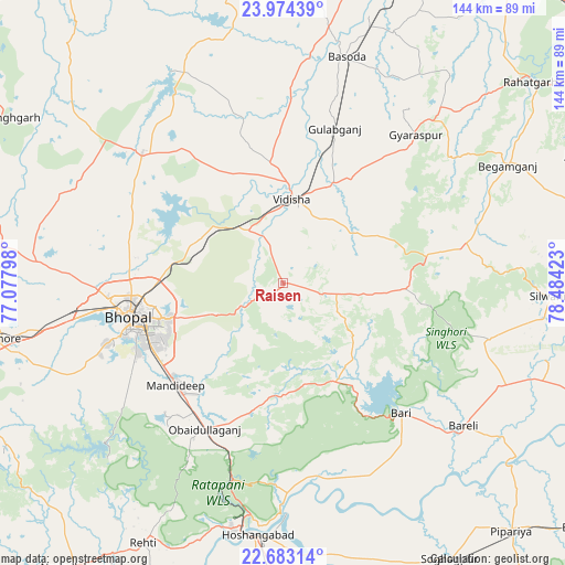
Raisen GPS coordinates[2]
23° 19' 49.188" North, 77° 46' 51.96" East
| Map corner | latitude | longitude |
|---|---|---|
| Upper-left | 23.97439°, | 77.07798° |
| Center: | 23.33033°, | 77.7811° |
| Lower-right: | 22.68314°, | 78.48423° |
| Map W x H: | 143.6×143.6 km | = 89.2×89.2mi |
| max Lat: | 34.9274° ⇑46.2% North |
| Raisen: | 23.33033° |
| min Lat: | ⇓53.8% South 8.09008° |
| min Long | Raisen | max Long |
| 68.82655° | 77.7811° | 96.81° |
| W 46.1%⇐ | ⇒53.9% E |
Elevation
Elevation of Raisen is 448 m = 1470 ft, and this is 152.4 m = 500 ft above average elevation for this country.
| Max E: |
3681 m = 12077 ft | 20.7% |
| Raisen | 448 m 1470 ft | |
| Avg. | 295.6 m = 970 ft | |
Min E: |
1 m = 3 ft | 79.3% |
See also: Raisen elevation on elevation.city.
Geographical zone
Raisen is located in North Torrid zone (between Equator and Tropic of Cancer). Distance of this Northern Tropic circle is 11.8 km =7.3 mi to North.| Distance of | km | miles | from Raisen |
|---|---|---|---|
| North Pole | 7413 | 4606.2 | to North |
| Arctic Circle | 4807.1 | 2987 | to North |
| Tropic Cancer | 11.8 | 7.3 | to North |
| Equator | 2594.1 | 1611.9 | to South |


Nearby cities:
15 places around Raisen: (largest is in red/bold)
• Begamganj
64.4 km =40 mi,  62°
62°
• Berasia
48.8 km =30.3 mi,  313°
313°
• Bhopal
39.5 km =24.5 mi,  257°
257°
• Bābai
71.6 km =44.5 mi,  167°
167°
• Bāsoda
60.1 km =37.3 mi,  15°
15°
• Chandpura
76.2 km =47.3 mi,  319°
319°
• Garha Brahman
73.8 km =45.9 mi, 324°
• Hoshangābād
65 km =40.4 mi,  184°
184°
• Mandideep
37.5 km =23.3 mi,  222°
222°
• Patalpani
71.6 km =44.5 mi, 322°
• Rehti
74.8 km =46.5 mi,  208°
208°
• Sehore
72.7 km =45.2 mi, 258°
• Sultānpur
26.5 km =16.5 mi,  143°
143°
• Sānchi
17.9 km =11.1 mi,  345°
345°
• Vidisha
22 km =13.7 mi,  7°
7°
Sources, notices
• [Note1] Compared only with cities in India existing in our database
• [Src1] Map data: © OpenStreetMap contributors (CC-BY-SA)
• [Src2] Other city data from geonames.org with taken over terms of usage.
• [Src3] Geographical zone / Annual Mean Temperature by Robert A. Rohde @ Wikipedia
