Sohāgpur geodata
Sohāgpur (Madhya Pradesh) is a populated place; located in India in Asia/Kolkata (GMT+5.5) time zone. With population of 23,849 people, there are 1779 cities with bigger population in this country. Compared to other cities in India, 51% of cities are located further ↑North; 51% of cities are located further ←West and 70.6% of cities have lower elevation than Sohāgpur. Note1


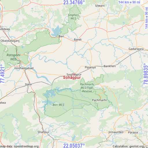
Sohāgpur GPS coordinates[2]
22° 42' 1.98" North, 78° 11' 42.792" East
| Map corner | latitude | longitude |
|---|---|---|
| Upper-left | 23.34766°, | 77.4921° |
| Center: | 22.70055°, | 78.19522° |
| Lower-right: | 22.05037°, | 78.89835° |
| Map W x H: | 144.2×144.2 km | = 89.6×89.6mi |
| max Lat: | 34.9274° ⇑51% North |
| Sohāgpur: | 22.70055° |
| min Lat: | ⇓49% South 8.09008° |
| min Long | Sohāgpur | max Long |
| 68.82655° | 78.19522° | 96.81° |
| W 51%⇐ | ⇒49% E |
Elevation
Elevation of Sohāgpur is 333 m = 1093 ft, and this is 37.4 m = 123 ft above average elevation for this country.
| Max E: |
3681 m = 12077 ft | 29.4% |
| Sohāgpur | 333 m 1093 ft | |
| Avg. | 295.6 m = 970 ft | |
Min E: |
1 m = 3 ft | 70.6% |
See also: India elevation on elevation.city.
Geographical zone
Sohāgpur is located in North Torrid zone (between Equator and Tropic of Cancer). Distance of this Northern Tropic circle is 81.9 km =50.9 mi to North.| Distance of | km | miles | from Sohāgpur |
|---|---|---|---|
| North Pole | 7483 | 4649.7 | to North |
| Arctic Circle | 4877.1 | 3030.5 | to North |
| Tropic Cancer | 81.9 | 50.9 | to North |
| Equator | 2524.1 | 1568.4 | to South |


Nearby cities:
15 places around Sohāgpur: (largest is in red/bold)
• Bābai
26.7 km =16.6 mi,  270°
270°
• Chichli
66.4 km =41.3 mi,  77°
77°
• Gādarwāra
65.3 km =40.6 mi,  67°
67°
• Hoshangābād
48.3 km =30 mi,  276°
276°
• Itārsi
45.4 km =28.2 mi,  257°
257°
• Jaithāri
71 km =44.1 mi,  37°
37°
• Jāmai
69.3 km =43.1 mi,  143°
143°
• Mandideep
80 km =49.7 mi,  302°
302°
• Pachmarhi
35.6 km =22.1 mi, 136°
• Panara
66.1 km =41.1 mi,  146°
146°
• Rehti
78.2 km =48.6 mi, 273°
• Seoni Mālwa
79.8 km =49.6 mi,  249°
249°
• Shāhpur
63.5 km =39.5 mi,  207°
207°
• Sultānpur
55.5 km =34.5 mi,  331°
331°
• Udaipura
52.7 km =32.7 mi, 37°
Sources, notices
• [Note1] Compared only with cities in India existing in our database
• [Src1] Map data: © OpenStreetMap contributors (CC-BY-SA)
• [Src2] Other city data from geonames.org with taken over terms of usage.
• [Src3] Geographical zone / Annual Mean Temperature by Robert A. Rohde @ Wikipedia
