Palwancha geodata
Palwancha (Telangana) is a populated place; located in India in Asia/Kolkata (GMT+5.5) time zone. With population of 68,561 people, there are 631 cities with bigger population in this country. Compared to other cities in India, 73% of cities are located further ↑North; 71.7% of cities are located further ←West and 71.2% of cities have higher elevation than Palwancha. Note1


Palwancha GPS coordinates[2]
17° 34' 53.472" North, 80° 40' 35.436" East
| Map corner | latitude | longitude |
|---|---|---|
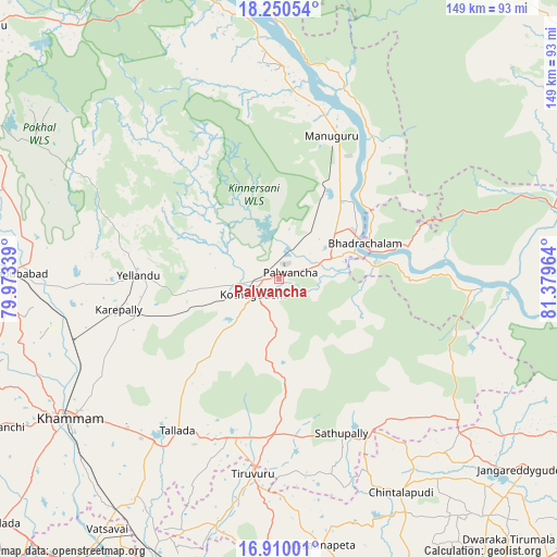
| Upper-left | 18.25054°, | 79.97339° |
| Center: | 17.58152°, | 80.67651° |
| Lower-right: | 16.91001°, | 81.37964° |
| Map W x H: | 149.1×149.1 km | = 92.6×92.6mi |
| max Lat: | 34.9274° ⇑73% North |
| Palwancha: | 17.58152° |
| min Lat: | ⇓27% South 8.09008° |
| min Long | Palwancha | max Long |
| 68.82655° | 80.67651° | 96.81° |
| W 71.7%⇐ | ⇒28.3% E |
Elevation
Elevation of Palwancha is 87 m = 285 ft, and this is 208.6 m = 684 ft below average elevation for this country.
| Max E: |
3681 m = 12077 ft | 71.2% |
| Avg. | 295.6 m = 970 ft | |
| Palwancha | 87 m = 285 ft | |
Min E: |
1 m = 3 ft | 28.8% |
See also: Palwancha elevation on elevation.city.
Geographical zone
Palwancha is located in North Torrid zone (between Equator and Tropic of Cancer). Distance of this Northern Tropic circle is 651 km =404.5 mi to North.| Distance of | km | miles | from Palwancha |
|---|---|---|---|
| North Pole | 8052.2 | 5003.4 | to North |
| Arctic Circle | 5446.3 | 3384.2 | to North |
| Tropic Cancer | 651 | 404.5 | to North |
| Equator | 1954.9 | 1214.7 | to South |


Nearby cities:
15 places around Palwancha: (largest is in red/bold)
• Bhadrāchalam
24.5 km =15.2 mi,  66°
66°
• Bhupalpally
105.9 km =65.8 mi,  311°
311°
• Chātakonda
4.4 km =2.7 mi,  223°
223°
• Dornakal
58 km =36 mi,  254°
254°
• Jaggayyapeta
98.1 km =61 mi, 218°
• Khammam
67.6 km =42 mi,  236°
236°
• Kodār
99.5 km =61.8 mi,  229°
229°
• Kottagūdem
7.1 km =4.4 mi, 241°
• Mahbūbābād
71.5 km =44.4 mi,  271°
271°
• Manuguru
45.2 km =28.1 mi,  10°
10°
• Nandigāma
99.1 km =61.6 mi,  204°
204°
• Nūzvīd
90 km =55.9 mi,  168°
168°
• Pāloncha
3.8 km =2.4 mi,  53°
53°
• Sathupalli
42.2 km =26.2 mi,  151°
151°
• Yellandu
37.6 km =23.4 mi, 271°
Sources, notices
• [Note1] Compared only with cities in India existing in our database
• [Src1] Map data: © OpenStreetMap contributors (CC-BY-SA)
• [Src2] Other city data from geonames.org with taken over terms of usage.
• [Src3] Geographical zone / Annual Mean Temperature by Robert A. Rohde @ Wikipedia
