Kottagūdem geodata
Kottagūdem (Telangana) is a seat of a second-order administrative division; located in India in Asia/Kolkata (GMT+5.5) time zone. With population of 79,247 people, there are 551 cities with bigger population in this country. Compared to other cities in India, 73.1% of cities are located further ↑North; 71.4% of cities are located further ←West and 65.8% of cities have higher elevation than Kottagūdem. Note1


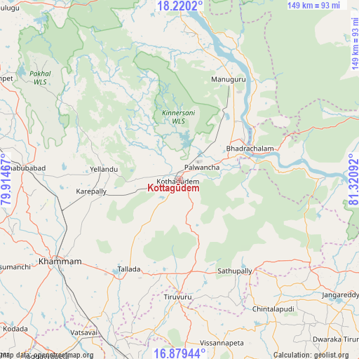
Kottagūdem GPS coordinates[2]
17° 33' 3.816" North, 80° 37' 4.044" East
| Map corner | latitude | longitude |
|---|---|---|
| Upper-left | 18.2202°, | 79.91467° |
| Center: | 17.55106°, | 80.61779° |
| Lower-right: | 16.87944°, | 81.32092° |
| Map W x H: | 149.1×149.1 km | = 92.6×92.6mi |
| max Lat: | 34.9274° ⇑73.1% North |
| Kottagūdem: | 17.55106° |
| min Lat: | ⇓26.9% South 8.09008° |
| min Long | Kottagūdem | max Long |
| 68.82655° | 80.61779° | 96.81° |
| W 71.4%⇐ | ⇒28.6% E |
Elevation
Elevation of Kottagūdem is 115 m = 377 ft, and this is 180.6 m = 593 ft below average elevation for this country.
| Max E: |
3681 m = 12077 ft | 65.8% |
| Avg. | 295.6 m = 970 ft | |
| Kottagūdem | 115 m = 377 ft | |
Min E: |
1 m = 3 ft | 34.2% |
See also: Kottagūdem elevation on elevation.city.
Geographical zone
Kottagūdem is located in North Torrid zone (between Equator and Tropic of Cancer). Distance of this Northern Tropic circle is 654.4 km =406.6 mi to North.| Distance of | km | miles | from Kottagūdem |
|---|---|---|---|
| North Pole | 8055.6 | 5005.5 | to North |
| Arctic Circle | 5449.7 | 3386.3 | to North |
| Tropic Cancer | 654.4 | 406.6 | to North |
| Equator | 1951.5 | 1212.6 | to South |


Nearby cities:
15 places around Kottagūdem: (largest is in red/bold)
• Bhadrāchalam
31.6 km =19.6 mi,  65°
65°
• Bhupalpally
103.7 km =64.4 mi,  315°
315°
• Chātakonda
3.2 km =2 mi,  86°
86°
• Dornakal
51.1 km =31.8 mi,  256°
256°
• Jaggayyapeta
91.6 km =56.9 mi,  217°
217°
• Khammam
60.6 km =37.7 mi,  236°
236°
• Kodār
92.6 km =57.5 mi,  228°
228°
• Mahbūbābād
65.5 km =40.7 mi,  274°
274°
• Manuguru
50 km =31.1 mi,  16°
16°
• Nandigāma
93.6 km =58.2 mi,  202°
202°
• Nūzvīd
88.2 km =54.8 mi,  164°
164°
• Palwancha
7.1 km =4.4 mi,  61°
61°
• Pāloncha
10.8 km =6.7 mi, 58°
• Sathupalli
42.8 km =26.6 mi,  141°
141°
• Yellandu
31.7 km =19.7 mi,  277°
277°
Sources, notices
• [Note1] Compared only with cities in India existing in our database
• [Src1] Map data: © OpenStreetMap contributors (CC-BY-SA)
• [Src2] Other city data from geonames.org with taken over terms of usage.
• [Src3] Geographical zone / Annual Mean Temperature by Robert A. Rohde @ Wikipedia
