Chātakonda geodata
Chātakonda (Telangana) is a populated place; located in India in Asia/Kolkata (GMT+5.5) time zone. With population of 2,816 people, there are 3418 cities with bigger population in this country. Compared to other cities in India, 73% of cities are located further ↑North; 71.5% of cities are located further ←West and 68.5% of cities have higher elevation than Chātakonda. Note1


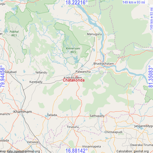
Chātakonda GPS coordinates[2]
17° 33' 10.908" North, 80° 38' 51.72" East
| Map corner | latitude | longitude |
|---|---|---|
| Upper-left | 18.22216°, | 79.94458° |
| Center: | 17.55303°, | 80.6477° |
| Lower-right: | 16.88142°, | 81.35083° |
| Map W x H: | 149.1×149.1 km | = 92.6×92.6mi |
| max Lat: | 34.9274° ⇑73% North |
| Chātakonda: | 17.55303° |
| min Lat: | ⇓27% South 8.09008° |
| min Long | Chātakonda | max Long |
| 68.82655° | 80.6477° | 96.81° |
| W 71.5%⇐ | ⇒28.5% E |
Elevation
Elevation of Chātakonda is 100 m = 328 ft, and this is 195.6 m = 642 ft below average elevation for this country.
| Max E: |
3681 m = 12077 ft | 68.5% |
| Avg. | 295.6 m = 970 ft | |
| Chātakonda | 100 m = 328 ft | |
Min E: |
1 m = 3 ft | 31.5% |
See also: India elevation on elevation.city.
Geographical zone
Chātakonda is located in North Torrid zone (between Equator and Tropic of Cancer). Distance of this Northern Tropic circle is 654.2 km =406.5 mi to North.| Distance of | km | miles | from Chātakonda |
|---|---|---|---|
| North Pole | 8055.3 | 5005.3 | to North |
| Arctic Circle | 5449.5 | 3386.2 | to North |
| Tropic Cancer | 654.2 | 406.5 | to North |
| Equator | 1951.7 | 1212.7 | to South |


Nearby cities:
15 places around Chātakonda: (largest is in red/bold)
• Bhadrāchalam
28.6 km =17.8 mi,  63°
63°
• Dornakal
54.2 km =33.7 mi,  257°
257°
• Jaggayyapeta
93.7 km =58.2 mi,  218°
218°
• Khammam
63.3 km =39.3 mi,  237°
237°
• Kodār
95.1 km =59.1 mi,  229°
229°
• Kondapalle
104.4 km =64.9 mi,  186°
186°
• Kottagūdem
3.2 km =2 mi,  266°
266°
• Mahbūbābād
68.6 km =42.6 mi, 274°
• Manuguru
48.9 km =30.4 mi,  13°
13°
• Nandigāma
95 km =59 mi,  203°
203°
• Nūzvīd
87.6 km =54.4 mi,  166°
166°
• Palwancha
4.4 km =2.7 mi,  43°
43°
• Pāloncha
8.2 km =5.1 mi,  48°
48°
• Sathupalli
41.1 km =25.5 mi,  145°
145°
• Yellandu
34.8 km =21.6 mi,  276°
276°
Sources, notices
• [Note1] Compared only with cities in India existing in our database
• [Src1] Map data: © OpenStreetMap contributors (CC-BY-SA)
• [Src2] Other city data from geonames.org with taken over terms of usage.
• [Src3] Geographical zone / Annual Mean Temperature by Robert A. Rohde @ Wikipedia
