Sarupathar geodata
Sarupathar (Assam) is a populated place; located in India in Asia/Kolkata (GMT+5.5) time zone. With population of 9,827 people, there are 2966 cities with bigger population in this country. Compared to other cities in India, 72% of cities are located further ↓South; 100% of cities are located further ←West and 54.2% of cities have lower elevation than Sarupathar. Note1


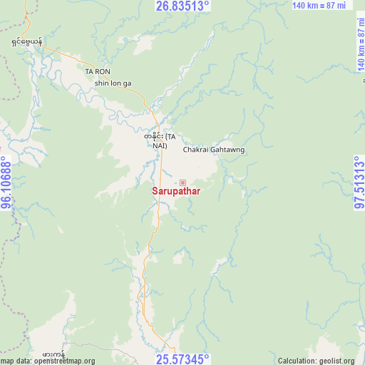
Sarupathar GPS coordinates[2]
26° 12' 21.6" North, 96° 48' 36" East
| Map corner | latitude | longitude |
|---|---|---|
| Upper-left | 26.83513°, | 96.10688° |
| Center: | 26.206°, | 96.81° |
| Lower-right: | 25.57345°, | 97.51313° |
| Map W x H: | 140.3×140.3 km | = 87.2×87.2mi |
| max Lat: | 34.9274° ⇑28% North |
| Sarupathar: | 26.206° |
| min Lat: | ⇓72% South 8.09008° |
| min Long | Sarupathar | max Long |
| 68.82655° | 96.81° | 96.81° |
| W 100%⇐ | ⇒0% E |
Elevation
Elevation of Sarupathar is 223 m = 732 ft, and this is 72.6 m = 238 ft below average elevation for this country.
| Max E: |
3681 m = 12077 ft | 45.8% |
| Avg. | 295.6 m = 970 ft | |
| Sarupathar | 223 m = 732 ft | |
Min E: |
1 m = 3 ft | 54.2% |
See also: India elevation on elevation.city.
Geographical zone
Sarupathar is located in North temperate zone (between Tropic of Cancer and the Arctic Circle). Distance of this Northern Tropic circle is 307.9 km =191.3 mi to South.| Distance of | km | miles | from Sarupathar |
|---|---|---|---|
| North Pole | 7093.2 | 4407.5 | to North |
| Arctic Circle | 4487.3 | 2788.3 | to North |
| Tropic Cancer | 307.9 | 191.3 | to South |
| Equator | 2913.8 | 1810.6 | to South |


Nearby cities:
15 places around Sarupathar: (largest is in red/bold)
• Digboi
177.2 km =110.1 mi,  318°
318°
• Duliāgaon
197.6 km =122.8 mi,  311°
311°
• Dum Duma
196 km =121.8 mi, 320°
• Hawai
186.9 km =116.1 mi,  359°
359°
• Khonsa
153 km =95.1 mi, 306°
• Longleng
201 km =124.9 mi,  279°
279°
• Margherita
165.1 km =102.6 mi, 316°
• Mon
184 km =114.3 mi,  288°
288°
• Mākum
197.1 km =122.5 mi, 316°
• Nahorkatiya
189.1 km =117.5 mi, 309°
• Namsai
187.8 km =116.7 mi,  330°
330°
• Nāmrup
184.4 km =114.6 mi, 306°
• Sonāri
200.2 km =124.4 mi,  297°
297°
• Tezu
201.4 km =125.1 mi,  340°
340°
• Tuensang
198.2 km =123.2 mi,  271°
271°
Sources, notices
• [Note1] Compared only with cities in India existing in our database
• [Src1] Map data: © OpenStreetMap contributors (CC-BY-SA)
• [Src2] Other city data from geonames.org with taken over terms of usage.
• [Src3] Geographical zone / Annual Mean Temperature by Robert A. Rohde @ Wikipedia
