Longleng geodata
Longleng (Nagaland) is a seat of a second-order administrative division; located in India in Asia/Kolkata (GMT+5.5) time zone. In our database, there are 3475 cities with bigger population. Compared to other cities in India, 74.5% of cities are located further ↓South; 99.3% of cities are located further ←West and 97% of cities have lower elevation than Longleng. Note1


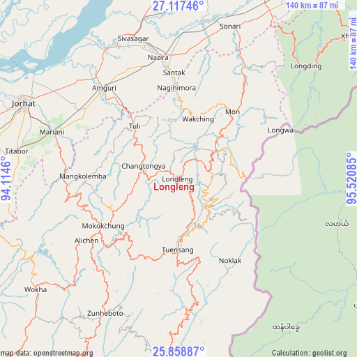
Longleng GPS coordinates[2]
26° 29' 23.604" North, 94° 49' 3.792" East
| Map corner | latitude | longitude |
|---|---|---|
| Upper-left | 27.11746°, | 94.1146° |
| Center: | 26.48989°, | 94.81772° |
| Lower-right: | 25.85887°, | 95.52085° |
| Map W x H: | 139.9×139.9 km | = 86.9×86.9mi |
| max Lat: | 34.9274° ⇑25.5% North |
| Longleng: | 26.48989° |
| min Lat: | ⇓74.5% South 8.09008° |
| min Long | Longleng | max Long |
| 68.82655° | 94.81772° | 96.81° |
| W 99.3%⇐ | ⇒0.7% E |
Elevation
Elevation of Longleng is 1265 m = 4150 ft, and this is 969.4 m = 3180 ft above average elevation for this country.
| Max E: |
3681 m = 12077 ft | 3% |
| Longleng | 1265 m 4150 ft | |
| Avg. | 295.6 m = 970 ft | |
Min E: |
1 m = 3 ft | 97% |
See also: India elevation on elevation.city.
Geographical zone
Longleng is located in North temperate zone (between Tropic of Cancer and the Arctic Circle). Distance of this Northern Tropic circle is 339.5 km =211 mi to South.| Distance of | km | miles | from Longleng |
|---|---|---|---|
| North Pole | 7061.7 | 4387.9 | to North |
| Arctic Circle | 4455.8 | 2768.7 | to North |
| Tropic Cancer | 339.5 | 211 | to South |
| Equator | 2945.4 | 1830.2 | to South |


Nearby cities:
15 places around Longleng: (largest is in red/bold)
• Amguri
46.3 km =28.8 mi,  321°
321°
• Garamur
82 km =51 mi,  308°
308°
• Jorhāt
68 km =42.3 mi,  295°
295°
• Mariāni
53.3 km =33.1 mi,  290°
290°
• Mokokchūng
35 km =21.7 mi,  238°
238°
• Mon
36.3 km =22.6 mi,  41°
41°
• Morānha
78.2 km =48.6 mi,  7°
7°
• Nāzirā
48.1 km =29.9 mi,  350°
350°
• Sibsāgar
57.8 km =35.9 mi,  341°
341°
• Sonari
68.1 km =42.3 mi,  17°
17°
• Sonāri
62.6 km =38.9 mi, 18°
• Titābar
62.3 km =38.7 mi,  281°
281°
• Tuensang
24.8 km =15.4 mi,  178°
178°
• Wokha
70.8 km =44 mi,  231°
231°
• Zunheboto
65.5 km =40.7 mi,  207°
207°
Sources, notices
• [Note1] Compared only with cities in India existing in our database
• [Src1] Map data: © OpenStreetMap contributors (CC-BY-SA)
• [Src2] Other city data from geonames.org with taken over terms of usage.
• [Src3] Geographical zone / Annual Mean Temperature by Robert A. Rohde @ Wikipedia
