Tuensang geodata
Tuensang (Nagaland) is a populated place; located in India in Asia/Kolkata (GMT+5.5) time zone. With population of 33,748 people, there are 1290 cities with bigger population in this country. Compared to other cities in India, 72.6% of cities are located further ↓South; 99.4% of cities are located further ←West and 96.6% of cities have lower elevation than Tuensang. Note1


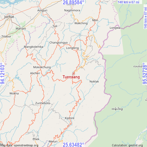
Tuensang GPS coordinates[2]
26° 16' 1.344" North, 94° 49' 26.94" East
| Map corner | latitude | longitude |
|---|---|---|
| Upper-left | 26.89584°, | 94.12103° |
| Center: | 26.26704°, | 94.82415° |
| Lower-right: | 25.63482°, | 95.52728° |
| Map W x H: | 140.2×140.2 km | = 87.1×87.1mi |
| max Lat: | 34.9274° ⇑27.4% North |
| Tuensang: | 26.26704° |
| min Lat: | ⇓72.6% South 8.09008° |
| min Long | Tuensang | max Long |
| 68.82655° | 94.82415° | 96.81° |
| W 99.4%⇐ | ⇒0.59999999999999% E |
Elevation
Elevation of Tuensang is 1122 m = 3681 ft, and this is 826.4 m = 2711 ft above average elevation for this country.
| Max E: |
3681 m = 12077 ft | 3.4% |
| Tuensang | 1122 m 3681 ft | |
| Avg. | 295.6 m = 970 ft | |
Min E: |
1 m = 3 ft | 96.6% |
See also: India elevation on elevation.city.
Geographical zone
Tuensang is located in North temperate zone (between Tropic of Cancer and the Arctic Circle). Distance of this Northern Tropic circle is 314.7 km =195.5 mi to South.| Distance of | km | miles | from Tuensang |
|---|---|---|---|
| North Pole | 7086.4 | 4403.3 | to North |
| Arctic Circle | 4480.6 | 2784.1 | to North |
| Tropic Cancer | 314.7 | 195.5 | to South |
| Equator | 2920.6 | 1814.8 | to South |


Nearby cities:
15 places around Tuensang: (largest is in red/bold)
• Amguri
67.7 km =42.1 mi,  334°
334°
• Golāghāt
90.3 km =56.1 mi,  287°
287°
• Jorhāt
82.4 km =51.2 mi,  311°
311°
• Longleng
24.8 km =15.4 mi,  358°
358°
• Mariāni
66.7 km =41.4 mi, 310°
• Mokokchūng
31.2 km =19.4 mi,  281°
281°
• Mon
57.1 km =35.5 mi,  24°
24°
• Nāzirā
72.7 km =45.2 mi,  353°
353°
• Phek
74.2 km =46.1 mi,  205°
205°
• Sibsāgar
81.9 km =50.9 mi, 346°
• Sonari
91.9 km =57.1 mi,  12°
12°
• Sonāri
86.4 km =53.7 mi, 12°
• Titābar
72.1 km =44.8 mi,  301°
301°
• Wokha
59.5 km =37 mi,  251°
251°
• Zunheboto
45.4 km =28.2 mi,  222°
222°
Sources, notices
• [Note1] Compared only with cities in India existing in our database
• [Src1] Map data: © OpenStreetMap contributors (CC-BY-SA)
• [Src2] Other city data from geonames.org with taken over terms of usage.
• [Src3] Geographical zone / Annual Mean Temperature by Robert A. Rohde @ Wikipedia
