Manihāri geodata
Manihāri (Bihar) is a populated place; located in India in Asia/Kolkata (GMT+5.5) time zone. With population of 23,731 people, there are 1786 cities with bigger population in this country. Compared to other cities in India, 65.6% of cities are located further ↓South; 90.4% of cities are located further ←West and 83% of cities have higher elevation than Manihāri. Note1


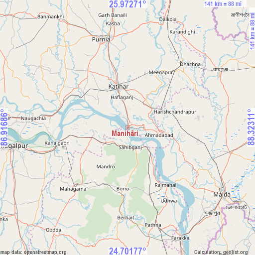
Manihāri GPS coordinates[2]
25° 20' 20.076" North, 87° 37' 11.928" East
| Map corner | latitude | longitude |
|---|---|---|
| Upper-left | 25.97271°, | 86.91686° |
| Center: | 25.33891°, | 87.61998° |
| Lower-right: | 24.70177°, | 88.32311° |
| Map W x H: | 141.3×141.3 km | = 87.8×87.8mi |
| max Lat: | 34.9274° ⇑34.4% North |
| Manihāri: | 25.33891° |
| min Lat: | ⇓65.6% South 8.09008° |
| min Long | Manihāri | max Long |
| 68.82655° | 87.61998° | 96.81° |
| W 90.4%⇐ | ⇒9.6% E |
Elevation
Elevation of Manihāri is 37 m = 121 ft, and this is 258.6 m = 848 ft below average elevation for this country.
| Max E: |
3681 m = 12077 ft | 83% |
| Avg. | 295.6 m = 970 ft | |
| Manihāri | 37 m = 121 ft | |
Min E: |
1 m = 3 ft | 17% |
See also: India elevation on elevation.city.
Geographical zone
Manihāri is located in North temperate zone (between Tropic of Cancer and the Arctic Circle). Distance of this Northern Tropic circle is 211.5 km =131.4 mi to South.| Distance of | km | miles | from Manihāri |
|---|---|---|---|
| North Pole | 7189.6 | 4467.4 | to North |
| Arctic Circle | 4583.8 | 2848.2 | to North |
| Tropic Cancer | 211.5 | 131.4 | to South |
| Equator | 2817.4 | 1750.7 | to South |


Nearby cities:
15 places around Manihāri: (largest is in red/bold)
• Baisi
59.6 km =37 mi,  12°
12°
• Bhāgalpur
66 km =41 mi,  260°
260°
• Colgong
39.8 km =24.7 mi, 257°
• Dalkola
63.6 km =39.5 mi,  20°
20°
• Farakka
64.6 km =40.1 mi,  154°
154°
• Ghoga
48.5 km =30.1 mi,  253°
253°
• Ingrāj Bāzār
64.7 km =40.2 mi,  125°
125°
• Kasba
58.1 km =36.1 mi,  351°
351°
• Katihar
22.7 km =14.1 mi, 347°
• Naugachhia
52.6 km =32.7 mi,  275°
275°
• Purnia
51.1 km =31.8 mi,  343°
343°
• Raghunāthpur
45.3 km =28.1 mi,  41°
41°
• Rāiganj
59.1 km =36.7 mi,  58°
58°
• Rājmahal
38.2 km =23.7 mi, 146°
• Sāhibganj
10.6 km =6.6 mi,  171°
171°
Sources, notices
• [Note1] Compared only with cities in India existing in our database
• [Src1] Map data: © OpenStreetMap contributors (CC-BY-SA)
• [Src2] Other city data from geonames.org with taken over terms of usage.
• [Src3] Geographical zone / Annual Mean Temperature by Robert A. Rohde @ Wikipedia
