Uklāna geodata
Uklāna (Haryana) is a populated place; located in India in Asia/Kolkata (GMT+5.5) time zone. With population of 11,908 people, there are 2750 cities with bigger population in this country. Compared to other cities in India, 91.1% of cities are located further ↓South; 75% of cities are located further →East and 54% of cities have lower elevation than Uklāna. Note1


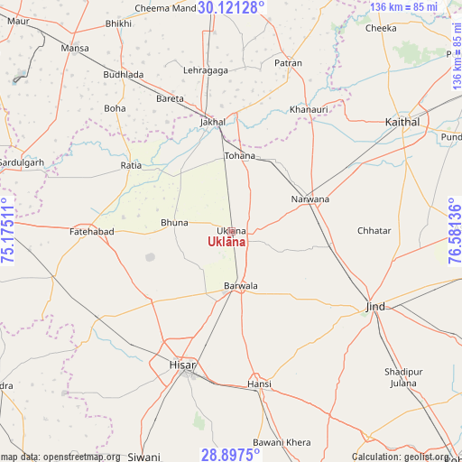
Uklāna GPS coordinates[2]
29° 30' 40.464" North, 75° 52' 41.628" East
| Map corner | latitude | longitude |
|---|---|---|
| Upper-left | 30.12128°, | 75.17511° |
| Center: | 29.51124°, | 75.87823° |
| Lower-right: | 28.8975°, | 76.58136° |
| Map W x H: | 136.1×136.1 km | = 84.6×84.6mi |
| max Lat: | 34.9274° ⇑8.9% North |
| Uklāna: | 29.51124° |
| min Lat: | ⇓91.1% South 8.09008° |
| min Long | Uklāna | max Long |
| 68.82655° | 75.87823° | 96.81° |
| W 25%⇐ | ⇒75% E |
Elevation
Elevation of Uklāna is 222 m = 728 ft, and this is 73.6 m = 241 ft below average elevation for this country.
| Max E: |
3681 m = 12077 ft | 46% |
| Avg. | 295.6 m = 970 ft | |
| Uklāna | 222 m = 728 ft | |
Min E: |
1 m = 3 ft | 54% |
See also: India elevation on elevation.city.
Geographical zone
Uklāna is located in North temperate zone (between Tropic of Cancer and the Arctic Circle). Distance of this Northern Tropic circle is 675.4 km =419.7 mi to South.| Distance of | km | miles | from Uklāna |
|---|---|---|---|
| North Pole | 6725.7 | 4179.2 | to North |
| Arctic Circle | 4119.8 | 2559.9 | to North |
| Tropic Cancer | 675.4 | 419.7 | to South |
| Equator | 3281.3 | 2038.9 | to South |


Nearby cities:
15 places around Uklāna: (largest is in red/bold)
• Akālgarh
34.4 km =21.4 mi,  2°
2°
• Bara Uchāna
29.4 km =18.3 mi,  99°
99°
• Barwāla
16.2 km =10.1 mi,  169°
169°
• Budhlāda
55.5 km =34.5 mi,  326°
326°
• Fatehābād
40.9 km =25.4 mi,  270°
270°
• Gorakhpur
21.2 km =13.2 mi,  250°
250°
• Hisar
42.5 km =26.4 mi,  200°
200°
• Hānsi
46.2 km =28.7 mi, 169°
• Inda Chhoi
16.7 km =10.4 mi, 329°
• Jākhal
32.1 km =19.9 mi,  350°
350°
• Jīnd
47.6 km =29.6 mi,  117°
117°
• Narwāna
25.3 km =15.7 mi,  67°
67°
• Nārnaund
41.3 km =25.7 mi,  141°
141°
• Ratia
35.3 km =21.9 mi,  304°
304°
• Tohāna
22.6 km =14 mi,  6°
6°
Sources, notices
• [Note1] Compared only with cities in India existing in our database
• [Src1] Map data: © OpenStreetMap contributors (CC-BY-SA)
• [Src2] Other city data from geonames.org with taken over terms of usage.
• [Src3] Geographical zone / Annual Mean Temperature by Robert A. Rohde @ Wikipedia
