Narwāna geodata
Narwāna (Haryana) is a populated place; located in India in Asia/Kolkata (GMT+5.5) time zone. With population of 55,850 people, there are 800 cities with bigger population in this country. Compared to other cities in India, 91.6% of cities are located further ↓South; 72.4% of cities are located further →East and 57.1% of cities have lower elevation than Narwāna. Note1


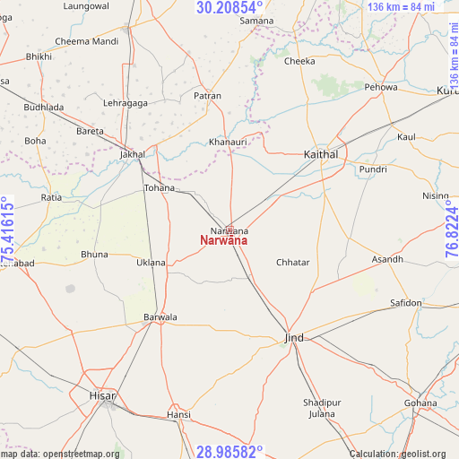
Narwāna GPS coordinates[2]
29° 35' 56.508" North, 76° 7' 9.372" East
| Map corner | latitude | longitude |
|---|---|---|
| Upper-left | 30.20854°, | 75.41615° |
| Center: | 29.59903°, | 76.11927° |
| Lower-right: | 28.98582°, | 76.8224° |
| Map W x H: | 136×136 km | = 84.5×84.5mi |
| max Lat: | 34.9274° ⇑8.4% North |
| Narwāna: | 29.59903° |
| min Lat: | ⇓91.6% South 8.09008° |
| min Long | Narwāna | max Long |
| 68.82655° | 76.11927° | 96.81° |
| W 27.6%⇐ | ⇒72.4% E |
Elevation
Elevation of Narwāna is 235 m = 771 ft, and this is 60.6 m = 199 ft below average elevation for this country.
| Max E: |
3681 m = 12077 ft | 42.9% |
| Avg. | 295.6 m = 970 ft | |
| Narwāna | 235 m = 771 ft | |
Min E: |
1 m = 3 ft | 57.1% |
See also: Narwāna elevation on elevation.city.
Geographical zone
Narwāna is located in North temperate zone (between Tropic of Cancer and the Arctic Circle). Distance of this Northern Tropic circle is 685.2 km =425.8 mi to South.| Distance of | km | miles | from Narwāna |
|---|---|---|---|
| North Pole | 6716 | 4173.1 | to North |
| Arctic Circle | 4110.1 | 2553.9 | to North |
| Tropic Cancer | 685.2 | 425.8 | to South |
| Equator | 3291.1 | 2045 | to South |


Nearby cities:
15 places around Narwāna: (largest is in red/bold)
• Akālgarh
33.1 km =20.6 mi,  318°
318°
• Bara Uchāna
15.7 km =9.8 mi,  158°
158°
• Barwāla
32.9 km =20.4 mi,  218°
218°
• Dirba
53.9 km =33.5 mi,  347°
347°
• Gorakhpur
46.4 km =28.8 mi,  248°
248°
• Inda Chhoi
32.1 km =19.9 mi,  278°
278°
• Jākhal
36 km =22.4 mi,  307°
307°
• Jīnd
36.8 km =22.9 mi,  148°
148°
• Kaithal
35.2 km =21.9 mi,  50°
50°
• Nārnaund
42.2 km =26.2 mi,  176°
176°
• Pūndri
46.3 km =28.8 mi,  67°
67°
• Ratia
53.4 km =33.2 mi, 280°
• Tohāna
24.3 km =15.1 mi,  301°
301°
• Uklāna
25.3 km =15.7 mi, 247°
• Āsandh
47.8 km =29.7 mi,  100°
100°
Sources, notices
• [Note1] Compared only with cities in India existing in our database
• [Src1] Map data: © OpenStreetMap contributors (CC-BY-SA)
• [Src2] Other city data from geonames.org with taken over terms of usage.
• [Src3] Geographical zone / Annual Mean Temperature by Robert A. Rohde @ Wikipedia
