Lātehār geodata
Lātehār (Jharkhand) is a populated place; located in India in Asia/Kolkata (GMT+5.5) time zone. With population of 20,769 people, there are 1985 cities with bigger population in this country. Compared to other cities in India, 56.4% of cities are located further ↓South; 83% of cities are located further ←West and 75.1% of cities have lower elevation than Lātehār. Note1


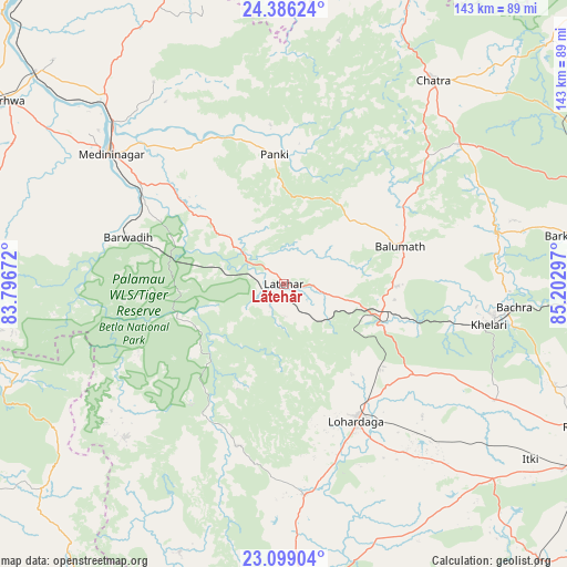
Lātehār GPS coordinates[2]
23° 44' 39.228" North, 84° 29' 59.424" East
| Map corner | latitude | longitude |
|---|---|---|
| Upper-left | 24.38624°, | 83.79672° |
| Center: | 23.74423°, | 84.49984° |
| Lower-right: | 23.09904°, | 85.20297° |
| Map W x H: | 143.1×143.1 km | = 88.9×88.9mi |
| max Lat: | 34.9274° ⇑43.6% North |
| Lātehār: | 23.74423° |
| min Lat: | ⇓56.4% South 8.09008° |
| min Long | Lātehār | max Long |
| 68.82655° | 84.49984° | 96.81° |
| W 83%⇐ | ⇒17% E |
Elevation
Elevation of Lātehār is 388 m = 1273 ft, and this is 92.4 m = 303 ft above average elevation for this country.
| Max E: |
3681 m = 12077 ft | 24.9% |
| Lātehār | 388 m 1273 ft | |
| Avg. | 295.6 m = 970 ft | |
Min E: |
1 m = 3 ft | 75.1% |
See also: India elevation on elevation.city.
Geographical zone
Lātehār is located in North temperate zone (between Tropic of Cancer and the Arctic Circle). Distance of this Northern Tropic circle is 34.2 km =21.3 mi to South.| Distance of | km | miles | from Lātehār |
|---|---|---|---|
| North Pole | 7367 | 4577.6 | to North |
| Arctic Circle | 4761.1 | 2958.4 | to North |
| Tropic Cancer | 34.2 | 21.3 | to South |
| Equator | 2640.1 | 1640.5 | to South |


Nearby cities:
15 places around Lātehār: (largest is in red/bold)
• Balrampur
91.7 km =57 mi,  260°
260°
• Barkā Kānā
99.5 km =61.8 mi,  97°
97°
• Barwādih
41.3 km =25.7 mi,  286°
286°
• Chatrā
63.7 km =39.6 mi,  36°
36°
• Daltonganj
55 km =34.2 mi,  306°
306°
• Garhwa
84.2 km =52.3 mi,  303°
303°
• Gumlā
78.1 km =48.5 mi,  176°
176°
• Hazāribāgh
91.9 km =57.1 mi,  72°
72°
• Kānke
90.4 km =56.2 mi,  112°
112°
• Lohārdagā
39.2 km =24.4 mi,  152°
152°
• Neturhāt
38.2 km =23.7 mi,  218°
218°
• Ranchi
93.8 km =58.3 mi,  118°
118°
• Rāmānuj Ganj
81.7 km =50.8 mi,  274°
274°
• Rāy
56.9 km =35.4 mi, 96°
• Sherghāti
95.4 km =59.3 mi,  18°
18°
Sources, notices
• [Note1] Compared only with cities in India existing in our database
• [Src1] Map data: © OpenStreetMap contributors (CC-BY-SA)
• [Src2] Other city data from geonames.org with taken over terms of usage.
• [Src3] Geographical zone / Annual Mean Temperature by Robert A. Rohde @ Wikipedia
