Surajpur geodata
Surajpur (Chhattisgarh) is a seat of a second-order administrative division; located in India in Asia/Kolkata (GMT+5.5) time zone. In our database, there are 3475 cities with bigger population. Compared to other cities in India, 53% of cities are located further ↓South; 78.9% of cities are located further ←West and 85.5% of cities have lower elevation than Surajpur. Note1


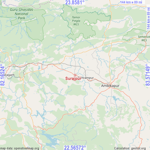
Surajpur GPS coordinates[2]
23° 12' 48.492" North, 82° 52' 6.096" East
| Map corner | latitude | longitude |
|---|---|---|
| Upper-left | 23.8581°, | 82.16524° |
| Center: | 23.21347°, | 82.86836° |
| Lower-right: | 22.56572°, | 83.57149° |
| Map W x H: | 143.7×143.7 km | = 89.3×89.3mi |
| max Lat: | 34.9274° ⇑47% North |
| Surajpur: | 23.21347° |
| min Lat: | ⇓53% South 8.09008° |
| min Long | Surajpur | max Long |
| 68.82655° | 82.86836° | 96.81° |
| W 78.9%⇐ | ⇒21.1% E |
Elevation
Elevation of Surajpur is 557 m = 1827 ft, and this is 261.4 m = 858 ft above average elevation for this country.
| Max E: |
3681 m = 12077 ft | 14.5% |
| Surajpur | 557 m 1827 ft | |
| Avg. | 295.6 m = 970 ft | |
Min E: |
1 m = 3 ft | 85.5% |
See also: India elevation on elevation.city.
Geographical zone
Surajpur is located in North Torrid zone (between Equator and Tropic of Cancer). Distance of this Northern Tropic circle is 24.8 km =15.4 mi to North.| Distance of | km | miles | from Surajpur |
|---|---|---|---|
| North Pole | 7426 | 4614.3 | to North |
| Arctic Circle | 4820.1 | 2995.1 | to North |
| Tropic Cancer | 24.8 | 15.4 | to North |
| Equator | 2581.1 | 1603.8 | to South |


Nearby cities:
15 places around Surajpur: (largest is in red/bold)
• Ambikāpur
35 km =21.7 mi,  107°
107°
• Anūppur
121 km =75.2 mi,  264°
264°
• Baikunthpur
31.9 km =19.8 mi,  279°
279°
• Balrampur
87.8 km =54.6 mi,  59°
59°
• Dūdhi
117.5 km =73 mi,  18°
18°
• Gaurela
111.4 km =69.2 mi,  242°
242°
• Katghora
85.8 km =53.3 mi,  202°
202°
• Korba
98.1 km =61 mi,  190°
190°
• Kotma
90.9 km =56.5 mi,  269°
269°
• Pasān
79.9 km =49.6 mi, 239°
• Pathalgaon
95.1 km =59.1 mi,  140°
140°
• Pendra
105 km =65.2 mi, 242°
• Renukūt
112.8 km =70.1 mi,  8°
8°
• Rāmānuj Ganj
107.4 km =66.7 mi,  52°
52°
• Singrauli
111.4 km =69.2 mi,  349°
349°
Sources, notices
• [Note1] Compared only with cities in India existing in our database
• [Src1] Map data: © OpenStreetMap contributors (CC-BY-SA)
• [Src2] Other city data from geonames.org with taken over terms of usage.
• [Src3] Geographical zone / Annual Mean Temperature by Robert A. Rohde @ Wikipedia
