Khekra geodata
Khekra (Uttar Pradesh) is a populated place; located in India in Asia/Kolkata (GMT+5.5) time zone. With population of 42,408 people, there are 1041 cities with bigger population in this country. Compared to other cities in India, 88.5% of cities are located further ↓South; 60.1% of cities are located further →East and 54.5% of cities have lower elevation than Khekra. Note1


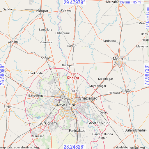
Khekra GPS coordinates[2]
28° 51' 57.096" North, 77° 17' 2.76" East
| Map corner | latitude | longitude |
|---|---|---|
| Upper-left | 29.47979°, | 76.58098° |
| Center: | 28.86586°, | 77.2841° |
| Lower-right: | 28.24828°, | 77.98723° |
| Map W x H: | 136.9×136.9 km | = 85.1×85.1mi |
| max Lat: | 34.9274° ⇑11.5% North |
| Khekra: | 28.86586° |
| min Lat: | ⇓88.5% South 8.09008° |
| min Long | Khekra | max Long |
| 68.82655° | 77.2841° | 96.81° |
| W 39.9%⇐ | ⇒60.1% E |
Elevation
Elevation of Khekra is 224 m = 735 ft, and this is 71.6 m = 235 ft below average elevation for this country.
| Max E: |
3681 m = 12077 ft | 45.5% |
| Avg. | 295.6 m = 970 ft | |
| Khekra | 224 m = 735 ft | |
Min E: |
1 m = 3 ft | 54.5% |
See also: Khekra elevation on elevation.city.
Geographical zone
Khekra is located in North temperate zone (between Tropic of Cancer and the Arctic Circle). Distance of this Northern Tropic circle is 603.7 km =375.1 mi to South.| Distance of | km | miles | from Khekra |
|---|---|---|---|
| North Pole | 6797.5 | 4223.8 | to North |
| Arctic Circle | 4191.6 | 2604.5 | to North |
| Tropic Cancer | 603.7 | 375.1 | to South |
| Equator | 3209.6 | 1994.4 | to South |


Nearby cities:
15 places around Khekra: (largest is in red/bold)
• Alīpur
16.5 km =10.3 mi,  243°
243°
• Baraut
26.3 km =16.3 mi,  355°
355°
• Bawāna
25.5 km =15.8 mi,  252°
252°
• Bāghpat
10.9 km =6.8 mi,  324°
324°
• Delhi
24.3 km =15.1 mi,  192°
192°
• Ghāziābād
26.9 km =16.7 mi,  145°
145°
• Karol Bāgh
25.5 km =15.8 mi,  200°
200°
• Loni
12.7 km =7.9 mi,  177°
177°
• Murādnagar
22.9 km =14.2 mi,  114°
114°
• Narela
18.7 km =11.6 mi,  265°
265°
• New Delhi
26.2 km =16.3 mi, 192°
• Niwāri
24.8 km =15.4 mi,  87°
87°
• Nāngloi Jāt
29.5 km =18.3 mi,  225°
225°
• Pitampura
24.6 km =15.3 mi,  217°
217°
• Rohini
25.1 km =15.6 mi, 237°
Sources, notices
• [Note1] Compared only with cities in India existing in our database
• [Src1] Map data: © OpenStreetMap contributors (CC-BY-SA)
• [Src2] Other city data from geonames.org with taken over terms of usage.
• [Src3] Geographical zone / Annual Mean Temperature by Robert A. Rohde @ Wikipedia
