Gangāpur geodata
Gangāpur (Maharashtra) is a populated place; located in India in Asia/Kolkata (GMT+5.5) time zone. With population of 24,118 people, there are 1763 cities with bigger population in this country. Compared to other cities in India, 66.2% of cities are located further ↑North; 82.7% of cities are located further →East and 81.6% of cities have lower elevation than Gangāpur. Note1


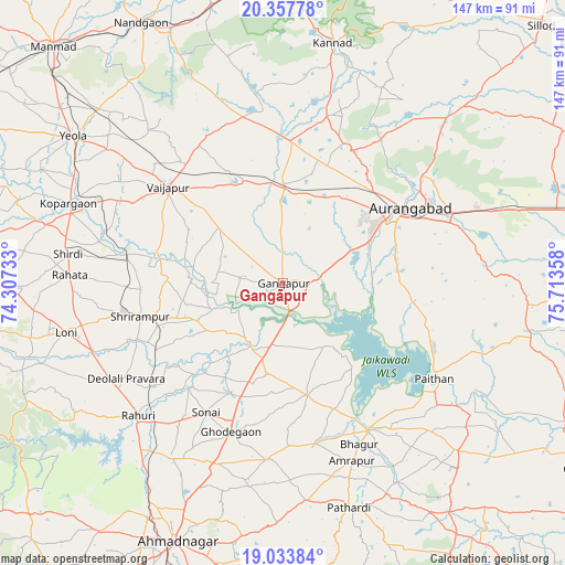
Gangāpur GPS coordinates[2]
19° 41' 49.848" North, 75° 0' 37.62" East
| Map corner | latitude | longitude |
|---|---|---|
| Upper-left | 20.35778°, | 74.30733° |
| Center: | 19.69718°, | 75.01045° |
| Lower-right: | 19.03384°, | 75.71358° |
| Map W x H: | 147.2×147.2 km | = 91.5×91.5mi |
| max Lat: | 34.9274° ⇑66.2% North |
| Gangāpur: | 19.69718° |
| min Lat: | ⇓33.8% South 8.09008° |
| min Long | Gangāpur | max Long |
| 68.82655° | 75.01045° | 96.81° |
| W 17.3%⇐ | ⇒82.7% E |
Elevation
Elevation of Gangāpur is 483 m = 1585 ft, and this is 187.4 m = 615 ft above average elevation for this country.
| Max E: |
3681 m = 12077 ft | 18.4% |
| Gangāpur | 483 m 1585 ft | |
| Avg. | 295.6 m = 970 ft | |
Min E: |
1 m = 3 ft | 81.6% |
See also: India elevation on elevation.city.
Geographical zone
Gangāpur is located in North Torrid zone (between Equator and Tropic of Cancer). Distance of this Northern Tropic circle is 415.8 km =258.4 mi to North.| Distance of | km | miles | from Gangāpur |
|---|---|---|---|
| North Pole | 7816.9 | 4857.2 | to North |
| Arctic Circle | 5211.1 | 3238 | to North |
| Tropic Cancer | 415.8 | 258.4 | to North |
| Equator | 2190.1 | 1360.9 | to South |


Nearby cities:
15 places around Gangāpur: (largest is in red/bold)
• Ahmadnagar
72.8 km =45.2 mi,  203°
203°
• Aurangabad
40.1 km =24.9 mi,  59°
59°
• Daulatābād
34.5 km =21.4 mi,  39°
39°
• Ellora
39.6 km =24.6 mi,  23°
23°
• Kannad
63.6 km =39.5 mi,  12°
12°
• Khuldābād
39.3 km =24.4 mi,  28°
28°
• Kopargaon
59.6 km =37 mi,  290°
290°
• Nāndgaon
77.3 km =48 mi,  331°
331°
• Paithan
46.4 km =28.8 mi,  122°
122°
• Pāthardi
60.8 km =37.8 mi,  163°
163°
• Pīpri
56 km =34.8 mi,  78°
78°
• Rāhuri
50.9 km =31.6 mi,  227°
227°
• Shirdi
56.3 km =35 mi,  277°
277°
• Vaijāpur
39.1 km =24.3 mi,  310°
310°
• Yeola
66.6 km =41.4 mi, 305°
Sources, notices
• [Note1] Compared only with cities in India existing in our database
• [Src1] Map data: © OpenStreetMap contributors (CC-BY-SA)
• [Src2] Other city data from geonames.org with taken over terms of usage.
• [Src3] Geographical zone / Annual Mean Temperature by Robert A. Rohde @ Wikipedia
