Ellora geodata
Ellora (Maharashtra) is a populated place; located in India in Asia/Kolkata (GMT+5.5) time zone. With population of 1,000 people, there are 3463 cities with bigger population in this country. Compared to other cities in India, 65.1% of cities are located further ↑North; 81.3% of cities are located further →East and 88.6% of cities have lower elevation than Ellora. Note1


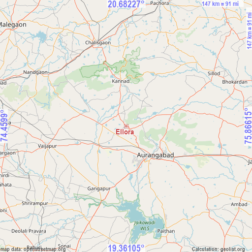
Ellora GPS coordinates[2]
20° 1' 22.98" North, 75° 9' 46.872" East
| Map corner | latitude | longitude |
|---|---|---|
| Upper-left | 20.68227°, | 74.4599° |
| Center: | 20.02305°, | 75.16302° |
| Lower-right: | 19.36105°, | 75.86615° |
| Map W x H: | 146.9×146.9 km | = 91.3×91.3mi |
| max Lat: | 34.9274° ⇑65.1% North |
| Ellora: | 20.02305° |
| min Lat: | ⇓34.9% South 8.09008° |
| min Long | Ellora | max Long |
| 68.82655° | 75.16302° | 96.81° |
| W 18.7%⇐ | ⇒81.3% E |
Elevation
Elevation of Ellora is 605 m = 1985 ft, and this is 309.4 m = 1015 ft above average elevation for this country.
| Max E: |
3681 m = 12077 ft | 11.4% |
| Ellora | 605 m 1985 ft | |
| Avg. | 295.6 m = 970 ft | |
Min E: |
1 m = 3 ft | 88.6% |
See also: India elevation on elevation.city.
Geographical zone
Ellora is located in North Torrid zone (between Equator and Tropic of Cancer). Distance of this Northern Tropic circle is 379.6 km =235.9 mi to North.| Distance of | km | miles | from Ellora |
|---|---|---|---|
| North Pole | 7780.7 | 4834.7 | to North |
| Arctic Circle | 5174.8 | 3215.5 | to North |
| Tropic Cancer | 379.6 | 235.9 | to North |
| Equator | 2226.4 | 1383.4 | to South |


Nearby cities:
15 places around Ellora: (largest is in red/bold)
• Aurangabad
24.8 km =15.4 mi,  130°
130°
• Chālisgaon
50.7 km =31.5 mi,  342°
342°
• Daulatābād
11.4 km =7.1 mi,  147°
147°
• Gangāpur
39.6 km =24.6 mi,  203°
203°
• Kannad
26.1 km =16.2 mi,  354°
354°
• Khuldābād
3.6 km =2.2 mi,  120°
120°
• Kopargaon
73.5 km =45.7 mi,  257°
257°
• Nāndgaon
61.7 km =38.3 mi,  300°
300°
• Paithan
65.2 km =40.5 mi,  159°
159°
• Pāchora
74.3 km =46.2 mi,  15°
15°
• Pīpri
46.5 km =28.9 mi, 123°
• Shirdi
77.2 km =48 mi,  248°
248°
• Sillod
59.9 km =37.2 mi,  58°
58°
• Vaijāpur
46.8 km =29.1 mi, 256°
• Yeola
70.4 km =43.7 mi,  271°
271°
Sources, notices
• [Note1] Compared only with cities in India existing in our database
• [Src1] Map data: © OpenStreetMap contributors (CC-BY-SA)
• [Src2] Other city data from geonames.org with taken over terms of usage.
• [Src3] Geographical zone / Annual Mean Temperature by Robert A. Rohde @ Wikipedia
