Pāliyād geodata
Pāliyād (Gujarat) is a populated place; located in India in Asia/Kolkata (GMT+5.5) time zone. With population of 10,862 people, there are 2848 cities with bigger population in this country. Compared to other cities in India, 54.7% of cities are located further ↑North; 98% of cities are located further →East and 65.8% of cities have higher elevation than Pāliyād. Note1


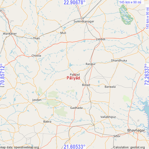
Pāliyād GPS coordinates[2]
22° 15' 27.252" North, 71° 33' 36.864" East
| Map corner | latitude | longitude |
|---|---|---|
| Upper-left | 22.90678°, | 70.85712° |
| Center: | 22.25757°, | 71.56024° |
| Lower-right: | 21.60533°, | 72.26337° |
| Map W x H: | 144.7×144.7 km | = 89.9×89.9mi |
| max Lat: | 34.9274° ⇑54.7% North |
| Pāliyād: | 22.25757° |
| min Lat: | ⇓45.3% South 8.09008° |
| min Long | Pāliyād | max Long |
| 68.82655° | 71.56024° | 96.81° |
| W 2%⇐ | ⇒98% E |
Elevation
Elevation of Pāliyād is 115 m = 377 ft, and this is 180.6 m = 593 ft below average elevation for this country.
| Max E: |
3681 m = 12077 ft | 65.8% |
| Avg. | 295.6 m = 970 ft | |
| Pāliyād | 115 m = 377 ft | |
Min E: |
1 m = 3 ft | 34.2% |
See also: India elevation on elevation.city.
Geographical zone
Pāliyād is located in North Torrid zone (between Equator and Tropic of Cancer). Distance of this Northern Tropic circle is 131.1 km =81.5 mi to North.| Distance of | km | miles | from Pāliyād |
|---|---|---|---|
| North Pole | 7532.3 | 4680.4 | to North |
| Arctic Circle | 4926.4 | 3061.1 | to North |
| Tropic Cancer | 131.1 | 81.5 | to North |
| Equator | 2474.8 | 1537.8 | to South |


Nearby cities:
15 places around Pāliyād: (largest is in red/bold)
• Botād
14.7 km =9.1 mi,  131°
131°
• Bābra
52.8 km =32.8 mi,  209°
209°
• Chotila
41.7 km =25.9 mi,  296°
296°
• Dhandhuka
46 km =28.6 mi,  72°
72°
• Dhola
47.2 km =29.3 mi,  152°
152°
• Gadhada
32.1 km =19.9 mi,  176°
176°
• Jasdan
43.8 km =27.2 mi,  235°
235°
• Limbdi
42.8 km =26.6 mi,  36°
36°
• Lāthi
62 km =38.5 mi,  196°
196°
• Surendranagar
53 km =32.9 mi,  9°
9°
• Sāyla
33.4 km =20.8 mi,  346°
346°
• Thān
51.1 km =31.8 mi,  313°
313°
• Umrāla
52.4 km =32.6 mi, 151°
• Valabhīpur
52.6 km =32.7 mi,  141°
141°
• Vinchia
19.3 km =12 mi,  254°
254°
Sources, notices
• [Note1] Compared only with cities in India existing in our database
• [Src1] Map data: © OpenStreetMap contributors (CC-BY-SA)
• [Src2] Other city data from geonames.org with taken over terms of usage.
• [Src3] Geographical zone / Annual Mean Temperature by Robert A. Rohde @ Wikipedia
