Dhone geodata
Dhone (Andhra Pradesh) is a populated place; located in India in Asia/Kolkata (GMT+5.5) time zone. With population of 39,689 people, there are 1116 cities with bigger population in this country. Compared to other cities in India, 80.4% of cities are located further ↑North; 52.7% of cities are located further →East and 77.6% of cities have lower elevation than Dhone. Note1


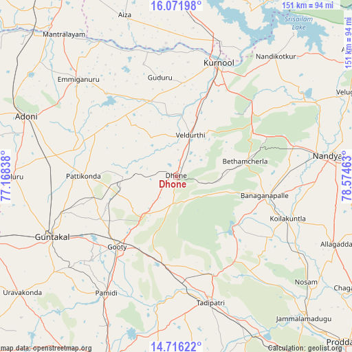
Dhone GPS coordinates[2]
15° 23' 42.72" North, 77° 52' 17.4" East
| Map corner | latitude | longitude |
|---|---|---|
| Upper-left | 16.07198°, | 77.16838° |
| Center: | 15.3952°, | 77.8715° |
| Lower-right: | 14.71622°, | 78.57463° |
| Map W x H: | 150.7×150.7 km | = 93.6×93.6mi |
| max Lat: | 34.9274° ⇑80.4% North |
| Dhone: | 15.3952° |
| min Lat: | ⇓19.6% South 8.09008° |
| min Long | Dhone | max Long |
| 68.82655° | 77.8715° | 96.81° |
| W 47.3%⇐ | ⇒52.7% E |
Elevation
Elevation of Dhone is 425 m = 1394 ft, and this is 129.4 m = 425 ft above average elevation for this country.
| Max E: |
3681 m = 12077 ft | 22.4% |
| Dhone | 425 m 1394 ft | |
| Avg. | 295.6 m = 970 ft | |
Min E: |
1 m = 3 ft | 77.6% |
See also: India elevation on elevation.city.
Geographical zone
Dhone is located in North Torrid zone (between Equator and Tropic of Cancer). Distance of this Northern Tropic circle is 894.1 km =555.6 mi to North.| Distance of | km | miles | from Dhone |
|---|---|---|---|
| North Pole | 8295.3 | 5154.5 | to North |
| Arctic Circle | 5689.4 | 3535.2 | to North |
| Tropic Cancer | 894.1 | 555.6 | to North |
| Equator | 1711.8 | 1063.7 | to South |


Nearby cities:
15 places around Dhone: (largest is in red/bold)
• Anantapur
84.6 km =52.6 mi,  199°
199°
• Banganapalle
39 km =24.2 mi,  102°
102°
• Betamcherla
30.3 km =18.8 mi,  78°
78°
• Emmiganūr
59 km =36.7 mi,  315°
315°
• Guntakal Junction
60 km =37.3 mi,  245°
245°
• Jammalamadugu
82.1 km =51 mi,  137°
137°
• Kosigi
84.4 km =52.4 mi,  307°
307°
• Kurnool
51.3 km =31.9 mi,  20°
20°
• Nandikotkūr
66.4 km =41.3 mi,  39°
39°
• Nandyāl
66.2 km =41.1 mi, 82°
• Rāmāpuram
12 km =7.5 mi,  182°
182°
• Tādpatri
56.1 km =34.9 mi,  164°
164°
• Uravakonda
83.1 km =51.6 mi,  232°
232°
• Ādoni
69 km =42.9 mi,  292°
292°
• Ālampur
60.8 km =37.8 mi,  27°
27°
Sources, notices
• [Note1] Compared only with cities in India existing in our database
• [Src1] Map data: © OpenStreetMap contributors (CC-BY-SA)
• [Src2] Other city data from geonames.org with taken over terms of usage.
• [Src3] Geographical zone / Annual Mean Temperature by Robert A. Rohde @ Wikipedia
