Rāmtek geodata
Rāmtek (Maharashtra) is a populated place; located in India in Asia/Kolkata (GMT+5.5) time zone. With population of 23,404 people, there are 1810 cities with bigger population in this country. Compared to other cities in India, 59.5% of cities are located further ↑North; 62.2% of cities are located further ←West and 70.9% of cities have lower elevation than Rāmtek. Note1


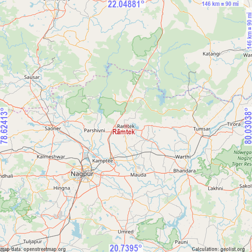
Rāmtek GPS coordinates[2]
21° 23' 44.232" North, 79° 19' 38.1" East
| Map corner | latitude | longitude |
|---|---|---|
| Upper-left | 22.04881°, | 78.62413° |
| Center: | 21.39562°, | 79.32725° |
| Lower-right: | 20.7395°, | 80.03038° |
| Map W x H: | 145.6×145.6 km | = 90.5×90.5mi |
| max Lat: | 34.9274° ⇑59.5% North |
| Rāmtek: | 21.39562° |
| min Lat: | ⇓40.5% South 8.09008° |
| min Long | Rāmtek | max Long |
| 68.82655° | 79.32725° | 96.81° |
| W 62.2%⇐ | ⇒37.8% E |
Elevation
Elevation of Rāmtek is 336 m = 1102 ft, and this is 40.4 m = 133 ft above average elevation for this country.
| Max E: |
3681 m = 12077 ft | 29.1% |
| Rāmtek | 336 m 1102 ft | |
| Avg. | 295.6 m = 970 ft | |
Min E: |
1 m = 3 ft | 70.9% |
See also: India elevation on elevation.city.
Geographical zone
Rāmtek is located in North Torrid zone (between Equator and Tropic of Cancer). Distance of this Northern Tropic circle is 226.9 km =141 mi to North.| Distance of | km | miles | from Rāmtek |
|---|---|---|---|
| North Pole | 7628.1 | 4739.9 | to North |
| Arctic Circle | 5022.2 | 3120.6 | to North |
| Tropic Cancer | 226.9 | 141 | to North |
| Equator | 2379 | 1478.2 | to South |


Nearby cities:
15 places around Rāmtek: (largest is in red/bold)
• Bhandāra
41.8 km =26 mi,  127°
127°
• Chicholi
39.6 km =24.6 mi,  78°
78°
• Hīrāpur Hamesha
50.7 km =31.5 mi,  69°
69°
• Kalmeshwar
45.9 km =28.5 mi,  246°
246°
• Khāpa
35.9 km =22.3 mi,  274°
274°
• Korādi
28.2 km =17.5 mi,  234°
234°
• Kāmthi
24.1 km =15 mi,  214°
214°
• Kāndri
5.9 km =3.7 mi,  297°
297°
• Lodhīkheda
52.7 km =32.7 mi,  293°
293°
• Mansar
6.6 km =4.1 mi, 270°
• Mohpa
52.4 km =32.6 mi,  259°
259°
• Nagpur
37.4 km =23.2 mi,  222°
222°
• Saoner
42 km =26.1 mi, 268°
• Tirodi
51.8 km =32.2 mi,  51°
51°
• Tumsar
42.1 km =26.2 mi,  91°
91°
Sources, notices
• [Note1] Compared only with cities in India existing in our database
• [Src1] Map data: © OpenStreetMap contributors (CC-BY-SA)
• [Src2] Other city data from geonames.org with taken over terms of usage.
• [Src3] Geographical zone / Annual Mean Temperature by Robert A. Rohde @ Wikipedia
