Pawni geodata
Pawni (Maharashtra) is a populated place; located in India in Asia/Kolkata (GMT+5.5) time zone. With population of 23,450 people, there are 1806 cities with bigger population in this country. Compared to other cities in India, 62.5% of cities are located further ↑North; 65% of cities are located further ←West and 59.6% of cities have lower elevation than Pawni. Note1


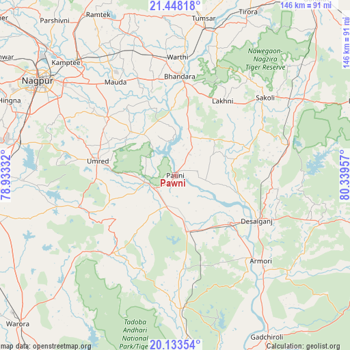
Pawni GPS coordinates[2]
20° 47' 32.244" North, 79° 38' 11.184" East
| Map corner | latitude | longitude |
|---|---|---|
| Upper-left | 21.44818°, | 78.93332° |
| Center: | 20.79229°, | 79.63644° |
| Lower-right: | 20.13354°, | 80.33957° |
| Map W x H: | 146.2×146.2 km | = 90.8×90.8mi |
| max Lat: | 34.9274° ⇑62.5% North |
| Pawni: | 20.79229° |
| min Lat: | ⇓37.5% South 8.09008° |
| min Long | Pawni | max Long |
| 68.82655° | 79.63644° | 96.81° |
| W 65%⇐ | ⇒35% E |
Elevation
Elevation of Pawni is 248 m = 814 ft, and this is 47.6 m = 156 ft below average elevation for this country.
| Max E: |
3681 m = 12077 ft | 40.4% |
| Avg. | 295.6 m = 970 ft | |
| Pawni | 248 m = 814 ft | |
Min E: |
1 m = 3 ft | 59.6% |
See also: India elevation on elevation.city.
Geographical zone
Pawni is located in North Torrid zone (between Equator and Tropic of Cancer). Distance of this Northern Tropic circle is 294 km =182.7 mi to North.| Distance of | km | miles | from Pawni |
|---|---|---|---|
| North Pole | 7695.2 | 4781.6 | to North |
| Arctic Circle | 5089.3 | 3162.3 | to North |
| Tropic Cancer | 294 | 182.7 | to North |
| Equator | 2311.9 | 1436.5 | to South |


Nearby cities:
15 places around Pawni: (largest is in red/bold)
• Bhandāra
41.8 km =26 mi,  1°
1°
• Chicholi
75.6 km =47 mi,  5°
5°
• Hinganghāt
87.2 km =54.2 mi,  251°
251°
• Hīrāpur Hamesha
86.3 km =53.6 mi, 10°
• Kalmeshwar
89 km =55.3 mi,  303°
303°
• Korādi
74.8 km =46.5 mi,  312°
312°
• Kāmthi
65.6 km =40.8 mi,  315°
315°
• Kāndri
79.2 km =49.2 mi,  331°
331°
• Mansar
77.5 km =48.2 mi, 330°
• Mūl
80.4 km =50 mi,  176°
176°
• Nagpur
69.5 km =43.2 mi, 304°
• Rāmtek
74.4 km =46.2 mi, 334°
• Sindi
77.9 km =48.4 mi,  271°
271°
• Tumsar
66.5 km =41.3 mi, 8°
• Umred
33.1 km =20.6 mi,  281°
281°
Sources, notices
• [Note1] Compared only with cities in India existing in our database
• [Src1] Map data: © OpenStreetMap contributors (CC-BY-SA)
• [Src2] Other city data from geonames.org with taken over terms of usage.
• [Src3] Geographical zone / Annual Mean Temperature by Robert A. Rohde @ Wikipedia
