Udgīr geodata
Udgīr (Maharashtra) is a populated place; located in India in Asia/Kolkata (GMT+5.5) time zone. With population of 101,064 people, there are 434 cities with bigger population in this country. Compared to other cities in India, 70.7% of cities are located further ↑North; 61.8% of cities are located further →East and 90.3% of cities have lower elevation than Udgīr. Note1


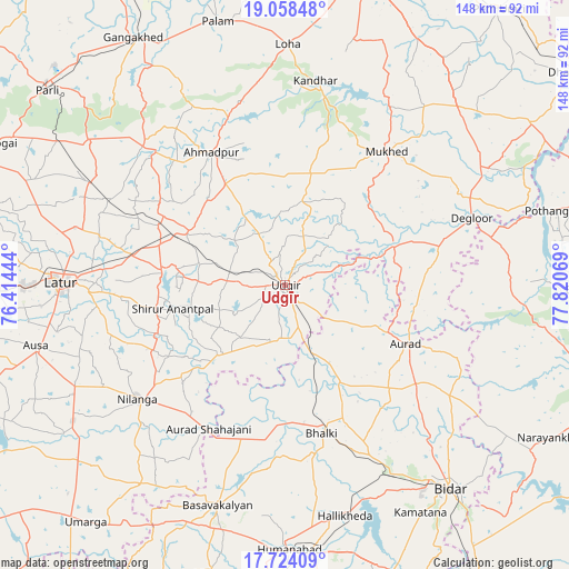
Udgīr GPS coordinates[2]
18° 23' 33.288" North, 77° 7' 3.216" East
| Map corner | latitude | longitude |
|---|---|---|
| Upper-left | 19.05848°, | 76.41444° |
| Center: | 18.39258°, | 77.11756° |
| Lower-right: | 17.72409°, | 77.82069° |
| Map W x H: | 148.4×148.4 km | = 92.2×92.2mi |
| max Lat: | 34.9274° ⇑70.7% North |
| Udgīr: | 18.39258° |
| min Lat: | ⇓29.3% South 8.09008° |
| min Long | Udgīr | max Long |
| 68.82655° | 77.11756° | 96.81° |
| W 38.2%⇐ | ⇒61.8% E |
Elevation
Elevation of Udgīr is 643 m = 2110 ft, and this is 347.4 m = 1140 ft above average elevation for this country.
| Max E: |
3681 m = 12077 ft | 9.7% |
| Udgīr | 643 m 2110 ft | |
| Avg. | 295.6 m = 970 ft | |
Min E: |
1 m = 3 ft | 90.3% |
See also: Udgīr elevation on elevation.city.
Geographical zone
Udgīr is located in North Torrid zone (between Equator and Tropic of Cancer). Distance of this Northern Tropic circle is 560.9 km =348.5 mi to North.| Distance of | km | miles | from Udgīr |
|---|---|---|---|
| North Pole | 7962 | 4947.4 | to North |
| Arctic Circle | 5356.1 | 3328.1 | to North |
| Tropic Cancer | 560.9 | 348.5 | to North |
| Equator | 2045.1 | 1270.8 | to South |


Nearby cities:
15 places around Udgīr: (largest is in red/bold)
• Ahmadpur
39.7 km =24.7 mi,  331°
331°
• Aurād
35.2 km =21.9 mi,  115°
115°
• Ausa
67.2 km =41.8 mi,  256°
256°
• Basavakalyān
60.3 km =37.5 mi,  197°
197°
• Bhālki
39.9 km =24.8 mi,  166°
166°
• Biloli
76.8 km =47.7 mi,  56°
56°
• Bānswāda
80.5 km =50 mi,  91°
91°
• Bīdar
68.8 km =42.8 mi,  140°
140°
• Dīglūr
51.4 km =31.9 mi,  70°
70°
• Gangākher
75 km =46.6 mi, 328°
• Homnābād
69.1 km =42.9 mi,  179°
179°
• Latur
58 km =36 mi,  270°
270°
• Mukher
43.7 km =27.2 mi,  37°
37°
• Nilanga
49.2 km =30.6 mi,  231°
231°
• Parli Vaijnāth
80 km =49.7 mi,  309°
309°
Sources, notices
• [Note1] Compared only with cities in India existing in our database
• [Src1] Map data: © OpenStreetMap contributors (CC-BY-SA)
• [Src2] Other city data from geonames.org with taken over terms of usage.
• [Src3] Geographical zone / Annual Mean Temperature by Robert A. Rohde @ Wikipedia
