Parli Vaijnāth geodata
Parli Vaijnāth (Maharashtra) is a populated place; located in India in Asia/Kolkata (GMT+5.5) time zone. With population of 94,863 people, there are 468 cities with bigger population in this country. Compared to other cities in India, 69.1% of cities are located further ↑North; 68% of cities are located further →East and 80.2% of cities have lower elevation than Parli Vaijnāth. Note1


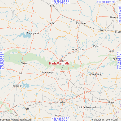
Parli Vaijnāth GPS coordinates[2]
18° 51' 2.052" North, 76° 31' 53.868" East
| Map corner | latitude | longitude |
|---|---|---|
| Upper-left | 19.51465°, | 75.82851° |
| Center: | 18.85057°, | 76.53163° |
| Lower-right: | 18.18385°, | 77.23476° |
| Map W x H: | 148×148 km | = 92×92mi |
| max Lat: | 34.9274° ⇑69.1% North |
| Parli Vaijnāth: | 18.85057° |
| min Lat: | ⇓30.9% South 8.09008° |
| min Long | Parli Vaijnāth | max Long |
| 68.82655° | 76.53163° | 96.81° |
| W 32%⇐ | ⇒68% E |
Elevation
Elevation of Parli Vaijnāth is 463 m = 1519 ft, and this is 167.4 m = 549 ft above average elevation for this country.
| Max E: |
3681 m = 12077 ft | 19.8% |
| Parli Vaijnāth | 463 m 1519 ft | |
| Avg. | 295.6 m = 970 ft | |
Min E: |
1 m = 3 ft | 80.2% |
See also: Parli Vaijnāth elevation on elevation.city.
Geographical zone
Parli Vaijnāth is located in North Torrid zone (between Equator and Tropic of Cancer). Distance of this Northern Tropic circle is 509.9 km =316.8 mi to North.| Distance of | km | miles | from Parli Vaijnāth |
|---|---|---|---|
| North Pole | 7911.1 | 4915.7 | to North |
| Arctic Circle | 5305.2 | 3296.5 | to North |
| Tropic Cancer | 509.9 | 316.8 | to North |
| Equator | 2096 | 1302.4 | to South |


Nearby cities:
15 places around Parli Vaijnāth: (largest is in red/bold)
• Ahmadpur
45.6 km =28.3 mi,  110°
110°
• Ambājogāi
20.1 km =12.5 mi,  229°
229°
• Ashti
66.8 km =41.5 mi,  331°
331°
• Ausa
67.2 km =41.8 mi,  182°
182°
• Beed
83 km =51.6 mi,  280°
280°
• Dhārūr
44.6 km =27.7 mi,  265°
265°
• Gangākher
26.5 km =16.5 mi,  59°
59°
• Latur
50.6 km =31.4 mi, 175°
• Mājalgaon
48.4 km =30.1 mi,  315°
315°
• Mānwat
50.2 km =31.2 mi,  355°
355°
• Parbhani
52.8 km =32.8 mi,  28°
28°
• Pāthri
46.5 km =28.9 mi,  347°
347°
• Pūrna
63.7 km =39.6 mi,  54°
54°
• Selu
67.9 km =42.2 mi, 351°
• Udgīr
80 km =49.7 mi,  129°
129°
Sources, notices
• [Note1] Compared only with cities in India existing in our database
• [Src1] Map data: © OpenStreetMap contributors (CC-BY-SA)
• [Src2] Other city data from geonames.org with taken over terms of usage.
• [Src3] Geographical zone / Annual Mean Temperature by Robert A. Rohde @ Wikipedia
