Mukher geodata
Mukher (Maharashtra) is a populated place; located in India in Asia/Kolkata (GMT+5.5) time zone. With population of 28,647 people, there are 1506 cities with bigger population in this country. Compared to other cities in India, 69.7% of cities are located further ↑North; 58.6% of cities are located further →East and 76.4% of cities have lower elevation than Mukher. Note1


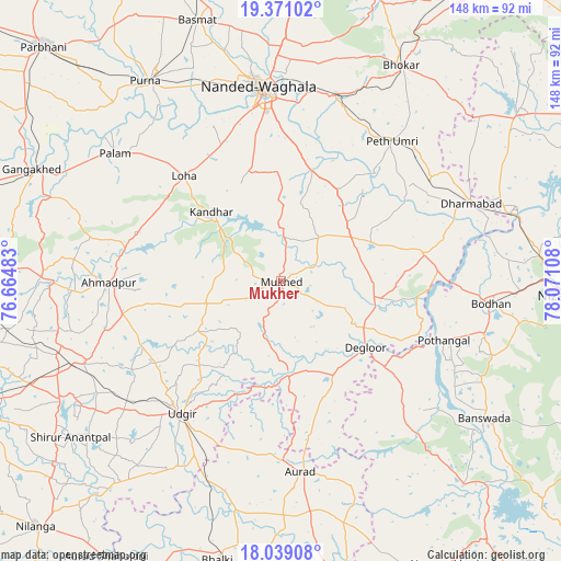
Mukher GPS coordinates[2]
18° 42' 22.896" North, 77° 22' 4.62" East
| Map corner | latitude | longitude |
|---|---|---|
| Upper-left | 19.37102°, | 76.66483° |
| Center: | 18.70636°, | 77.36795° |
| Lower-right: | 18.03908°, | 78.07108° |
| Map W x H: | 148.1×148.1 km | = 92×92mi |
| max Lat: | 34.9274° ⇑69.7% North |
| Mukher: | 18.70636° |
| min Lat: | ⇓30.3% South 8.09008° |
| min Long | Mukher | max Long |
| 68.82655° | 77.36795° | 96.81° |
| W 41.4%⇐ | ⇒58.6% E |
Elevation
Elevation of Mukher is 404 m = 1325 ft, and this is 108.4 m = 356 ft above average elevation for this country.
| Max E: |
3681 m = 12077 ft | 23.6% |
| Mukher | 404 m 1325 ft | |
| Avg. | 295.6 m = 970 ft | |
Min E: |
1 m = 3 ft | 76.4% |
See also: India elevation on elevation.city.
Geographical zone
Mukher is located in North Torrid zone (between Equator and Tropic of Cancer). Distance of this Northern Tropic circle is 526 km =326.8 mi to North.| Distance of | km | miles | from Mukher |
|---|---|---|---|
| North Pole | 7927.1 | 4925.7 | to North |
| Arctic Circle | 5321.2 | 3306.4 | to North |
| Tropic Cancer | 526 | 326.8 | to North |
| Equator | 2080 | 1292.5 | to South |


Nearby cities:
15 places around Mukher: (largest is in red/bold)
• Ahmadpur
45.4 km =28.2 mi,  269°
269°
• Aurād
50.6 km =31.4 mi,  174°
174°
• Basmat
72.7 km =45.2 mi,  342°
342°
• Bhālki
75.7 km =47 mi,  193°
193°
• Biloli
38.3 km =23.8 mi,  78°
78°
• Bodhan
54.8 km =34.1 mi,  95°
95°
• Bānswāda
65.2 km =40.5 mi,  124°
124°
• Dharmābād
54.7 km =34 mi,  67°
67°
• Dīglūr
28.2 km =17.5 mi,  128°
128°
• Gangākher
71.4 km =44.4 mi,  294°
294°
• Kondalwādi
43.8 km =27.2 mi, 75°
• Mudkhed
52 km =32.3 mi,  15°
15°
• Nanded
50.8 km =31.6 mi,  353°
353°
• Pūrna
63.9 km =39.7 mi,  325°
325°
• Udgīr
43.7 km =27.2 mi,  217°
217°
Sources, notices
• [Note1] Compared only with cities in India existing in our database
• [Src1] Map data: © OpenStreetMap contributors (CC-BY-SA)
• [Src2] Other city data from geonames.org with taken over terms of usage.
• [Src3] Geographical zone / Annual Mean Temperature by Robert A. Rohde @ Wikipedia
