Gangākher geodata
Gangākher (Maharashtra) is a populated place; located in India in Asia/Kolkata (GMT+5.5) time zone. With population of 46,366 people, there are 953 cities with bigger population in this country. Compared to other cities in India, 68.8% of cities are located further ↑North; 65.7% of cities are located further →East and 74.8% of cities have lower elevation than Gangākher. Note1


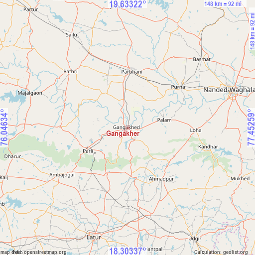
Gangākher GPS coordinates[2]
18° 58' 10.632" North, 76° 44' 58.056" East
| Map corner | latitude | longitude |
|---|---|---|
| Upper-left | 19.63322°, | 76.04634° |
| Center: | 18.96962°, | 76.74946° |
| Lower-right: | 18.30337°, | 77.45259° |
| Map W x H: | 147.9×147.9 km | = 91.9×91.9mi |
| max Lat: | 34.9274° ⇑68.8% North |
| Gangākher: | 18.96962° |
| min Lat: | ⇓31.2% South 8.09008° |
| min Long | Gangākher | max Long |
| 68.82655° | 76.74946° | 96.81° |
| W 34.3%⇐ | ⇒65.7% E |
Elevation
Elevation of Gangākher is 382 m = 1253 ft, and this is 86.4 m = 283 ft above average elevation for this country.
| Max E: |
3681 m = 12077 ft | 25.2% |
| Gangākher | 382 m 1253 ft | |
| Avg. | 295.6 m = 970 ft | |
Min E: |
1 m = 3 ft | 74.8% |
See also: Gangākher elevation on elevation.city.
Geographical zone
Gangākher is located in North Torrid zone (between Equator and Tropic of Cancer). Distance of this Northern Tropic circle is 496.7 km =308.6 mi to North.| Distance of | km | miles | from Gangākher |
|---|---|---|---|
| North Pole | 7897.8 | 4907.5 | to North |
| Arctic Circle | 5292 | 3288.3 | to North |
| Tropic Cancer | 496.7 | 308.6 | to North |
| Equator | 2109.2 | 1310.6 | to South |


Nearby cities:
15 places around Gangākher: (largest is in red/bold)
• Ahmadpur
35.3 km =21.9 mi,  145°
145°
• Ambājogāi
46.4 km =28.8 mi,  235°
235°
• Ashti
71.3 km =44.3 mi,  309°
309°
• Basmat
58.6 km =36.4 mi,  47°
47°
• Dhārūr
69.4 km =43.1 mi,  256°
256°
• Latur
66.5 km =41.3 mi,  196°
196°
• Mukher
71.4 km =44.4 mi,  114°
114°
• Mājalgaon
60.7 km =37.7 mi,  290°
290°
• Mānwat
45.4 km =28.2 mi,  324°
324°
• Nanded
63.1 km =39.2 mi,  70°
70°
• Parbhani
33.3 km =20.7 mi,  3°
3°
• Parli Vaijnāth
26.5 km =16.5 mi, 239°
• Pāthri
46.2 km =28.7 mi, 314°
• Pūrna
37.4 km =23.2 mi, 50°
• Selu
63 km =39.1 mi,  329°
329°
Sources, notices
• [Note1] Compared only with cities in India existing in our database
• [Src1] Map data: © OpenStreetMap contributors (CC-BY-SA)
• [Src2] Other city data from geonames.org with taken over terms of usage.
• [Src3] Geographical zone / Annual Mean Temperature by Robert A. Rohde @ Wikipedia
