Ausa geodata
Ausa (Maharashtra) is a populated place; located in India in Asia/Kolkata (GMT+5.5) time zone. With population of 34,161 people, there are 1271 cities with bigger population in this country. Compared to other cities in India, 71.2% of cities are located further ↑North; 68.5% of cities are located further →East and 90% of cities have lower elevation than Ausa. Note1


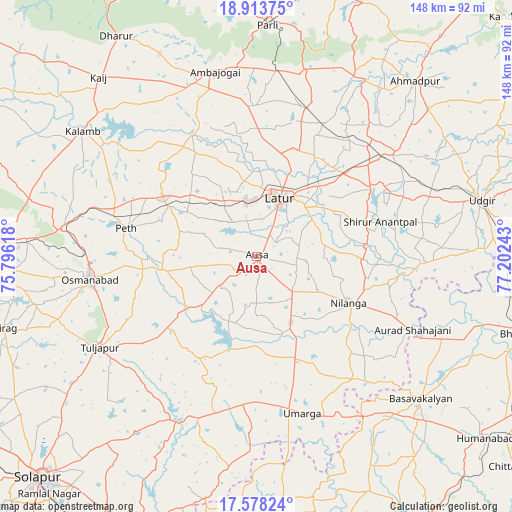
Ausa GPS coordinates[2]
18° 14' 50.208" North, 76° 29' 57.48" East
| Map corner | latitude | longitude |
|---|---|---|
| Upper-left | 18.91375°, | 75.79618° |
| Center: | 18.24728°, | 76.4993° |
| Lower-right: | 17.57824°, | 77.20243° |
| Map W x H: | 148.5×148.5 km | = 92.3×92.3mi |
| max Lat: | 34.9274° ⇑71.2% North |
| Ausa: | 18.24728° |
| min Lat: | ⇓28.8% South 8.09008° |
| min Long | Ausa | max Long |
| 68.82655° | 76.4993° | 96.81° |
| W 31.5%⇐ | ⇒68.5% E |
Elevation
Elevation of Ausa is 637 m = 2090 ft, and this is 341.4 m = 1120 ft above average elevation for this country.
| Max E: |
3681 m = 12077 ft | 10% |
| Ausa | 637 m 2090 ft | |
| Avg. | 295.6 m = 970 ft | |
Min E: |
1 m = 3 ft | 90% |
See also: India elevation on elevation.city.
Geographical zone
Ausa is located in North Torrid zone (between Equator and Tropic of Cancer). Distance of this Northern Tropic circle is 577 km =358.5 mi to North.| Distance of | km | miles | from Ausa |
|---|---|---|---|
| North Pole | 7978.2 | 4957.4 | to North |
| Arctic Circle | 5372.3 | 3338.2 | to North |
| Tropic Cancer | 577 | 358.5 | to North |
| Equator | 2028.9 | 1260.7 | to South |


Nearby cities:
15 places around Ausa: (largest is in red/bold)
• Ahmadpur
68.8 km =42.8 mi,  42°
42°
• Aland
76.3 km =47.4 mi,  174°
174°
• Ambājogāi
55.3 km =34.4 mi,  347°
347°
• Basavakalyān
63.1 km =39.2 mi,  131°
131°
• Dhārūr
75.8 km =47.1 mi,  327°
327°
• Kāti
71.9 km =44.7 mi,  243°
243°
• Latur
18.2 km =11.3 mi,  23°
23°
• Moram
51.1 km =31.8 mi,  183°
183°
• Naldurg
53.1 km =33 mi,  205°
205°
• Nilanga
30.5 km =19 mi,  118°
118°
• Osmanabad
49.2 km =30.6 mi,  261°
261°
• Parli Vaijnāth
67.2 km =41.8 mi,  2°
2°
• Tuljāpur
52.6 km =32.7 mi, 239°
• Udgīr
67.2 km =41.8 mi,  76°
76°
• Umarga
47.3 km =29.4 mi,  163°
163°
Sources, notices
• [Note1] Compared only with cities in India existing in our database
• [Src1] Map data: © OpenStreetMap contributors (CC-BY-SA)
• [Src2] Other city data from geonames.org with taken over terms of usage.
• [Src3] Geographical zone / Annual Mean Temperature by Robert A. Rohde @ Wikipedia
