Bānswāda geodata
Bānswāda (Telangana) is a populated place; located in India in Asia/Kolkata (GMT+5.5) time zone. With population of 22,665 people, there are 1858 cities with bigger population in this country. Compared to other cities in India, 70.8% of cities are located further ↑North; 52.6% of cities are located further →East and 75.1% of cities have lower elevation than Bānswāda. Note1


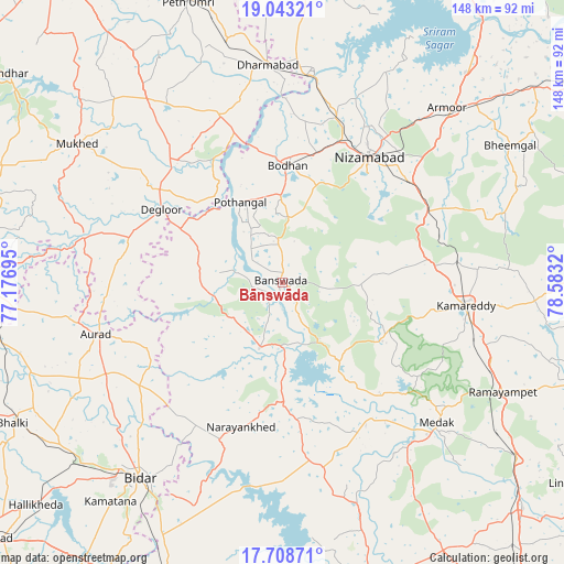
Bānswāda GPS coordinates[2]
18° 22' 38.1" North, 77° 52' 48.252" East
| Map corner | latitude | longitude |
|---|---|---|
| Upper-left | 19.04321°, | 77.17695° |
| Center: | 18.37725°, | 77.88007° |
| Lower-right: | 17.70871°, | 78.5832° |
| Map W x H: | 148.4×148.4 km | = 92.2×92.2mi |
| max Lat: | 34.9274° ⇑70.8% North |
| Bānswāda: | 18.37725° |
| min Lat: | ⇓29.2% South 8.09008° |
| min Long | Bānswāda | max Long |
| 68.82655° | 77.88007° | 96.81° |
| W 47.4%⇐ | ⇒52.6% E |
Elevation
Elevation of Bānswāda is 387 m = 1270 ft, and this is 91.4 m = 300 ft above average elevation for this country.
| Max E: |
3681 m = 12077 ft | 24.9% |
| Bānswāda | 387 m 1270 ft | |
| Avg. | 295.6 m = 970 ft | |
Min E: |
1 m = 3 ft | 75.1% |
See also: India elevation on elevation.city.
Geographical zone
Bānswāda is located in North Torrid zone (between Equator and Tropic of Cancer). Distance of this Northern Tropic circle is 562.6 km =349.6 mi to North.| Distance of | km | miles | from Bānswāda |
|---|---|---|---|
| North Pole | 7963.7 | 4948.4 | to North |
| Arctic Circle | 5357.8 | 3329.2 | to North |
| Tropic Cancer | 562.6 | 349.6 | to North |
| Equator | 2043.4 | 1269.7 | to South |


Nearby cities:
15 places around Bānswāda: (largest is in red/bold)
• Andol
65.9 km =40.9 mi,  161°
161°
• Aurād
50.7 km =31.5 mi,  254°
254°
• Bhālki
80.3 km =49.9 mi,  242°
242°
• Biloli
47 km =29.2 mi,  339°
339°
• Bodhan
31.7 km =19.7 mi,  1°
1°
• Bīdar
63.5 km =39.5 mi,  215°
215°
• Chandūr
60.5 km =37.6 mi, 157°
• Dharmābād
57.2 km =35.5 mi,  356°
356°
• Dīglūr
37.2 km =23.1 mi,  300°
300°
• Kondalwādi
49.2 km =30.6 mi,  346°
346°
• Kāmāreddi
49.1 km =30.5 mi,  97°
97°
• Medak
54.6 km =33.9 mi,  132°
132°
• Mukher
65.2 km =40.5 mi, 304°
• Nizāmābād
40 km =24.9 mi,  35°
35°
• Nārsingi
68.4 km =42.5 mi,  122°
122°
Sources, notices
• [Note1] Compared only with cities in India existing in our database
• [Src1] Map data: © OpenStreetMap contributors (CC-BY-SA)
• [Src2] Other city data from geonames.org with taken over terms of usage.
• [Src3] Geographical zone / Annual Mean Temperature by Robert A. Rohde @ Wikipedia
