Ahmadpur geodata
Ahmadpur (Maharashtra) is a populated place; located in India in Asia/Kolkata (GMT+5.5) time zone. With population of 40,218 people, there are 1094 cities with bigger population in this country. Compared to other cities in India, 69.7% of cities are located further ↑North; 63.9% of cities are located further →East and 84% of cities have lower elevation than Ahmadpur. Note1


Ahmadpur GPS coordinates[2]
18° 42' 22.392" North, 76° 56' 14.316" East
| Map corner | latitude | longitude |
|---|---|---|
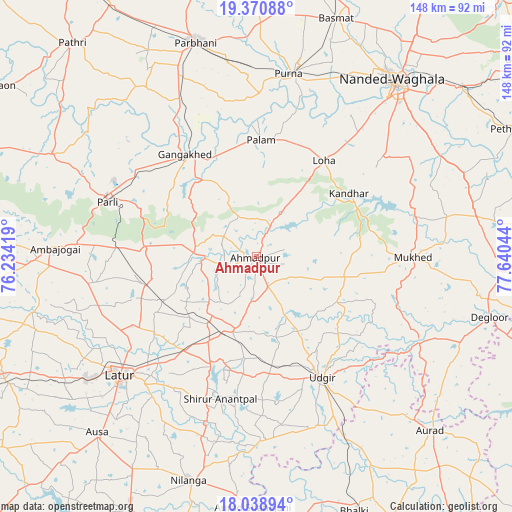
| Upper-left | 19.37088°, | 76.23419° |
| Center: | 18.70622°, | 76.93731° |
| Lower-right: | 18.03894°, | 77.64044° |
| Map W x H: | 148.1×148.1 km | = 92×92mi |
| max Lat: | 34.9274° ⇑69.7% North |
| Ahmadpur: | 18.70622° |
| min Lat: | ⇓30.3% South 8.09008° |
| min Long | Ahmadpur | max Long |
| 68.82655° | 76.93731° | 96.81° |
| W 36.1%⇐ | ⇒63.9% E |
Elevation
Elevation of Ahmadpur is 526 m = 1726 ft, and this is 230.4 m = 756 ft above average elevation for this country.
| Max E: |
3681 m = 12077 ft | 16% |
| Ahmadpur | 526 m 1726 ft | |
| Avg. | 295.6 m = 970 ft | |
Min E: |
1 m = 3 ft | 84% |
See also: Ahmadpur elevation on elevation.city.
Geographical zone
Ahmadpur is located in North Torrid zone (between Equator and Tropic of Cancer). Distance of this Northern Tropic circle is 526 km =326.8 mi to North.| Distance of | km | miles | from Ahmadpur |
|---|---|---|---|
| North Pole | 7927.1 | 4925.7 | to North |
| Arctic Circle | 5321.2 | 3306.4 | to North |
| Tropic Cancer | 526 | 326.8 | to North |
| Equator | 2079.9 | 1292.4 | to South |


Nearby cities:
15 places around Ahmadpur: (largest is in red/bold)
• Ambājogāi
58.1 km =36.1 mi,  272°
272°
• Aurād
71.4 km =44.4 mi,  134°
134°
• Ausa
68.8 km =42.8 mi,  222°
222°
• Basmat
73 km =45.4 mi,  18°
18°
• Dīglūr
69.6 km =43.2 mi,  104°
104°
• Gangākher
35.3 km =21.9 mi,  325°
325°
• Latur
51.9 km =32.2 mi,  228°
228°
• Mudkhed
77.8 km =48.3 mi,  49°
49°
• Mukher
45.4 km =28.2 mi,  89°
89°
• Nanded
64.2 km =39.9 mi,  38°
38°
• Nilanga
68.4 km =42.5 mi,  196°
196°
• Parbhani
64.9 km =40.3 mi,  344°
344°
• Parli Vaijnāth
45.6 km =28.3 mi,  290°
290°
• Pūrna
53.7 km =33.4 mi,  9°
9°
• Udgīr
39.7 km =24.7 mi,  151°
151°
Sources, notices
• [Note1] Compared only with cities in India existing in our database
• [Src1] Map data: © OpenStreetMap contributors (CC-BY-SA)
• [Src2] Other city data from geonames.org with taken over terms of usage.
• [Src3] Geographical zone / Annual Mean Temperature by Robert A. Rohde @ Wikipedia
