Thandla geodata
Thandla (Madhya Pradesh) is a populated place; located in India in Asia/Kolkata (GMT+5.5) time zone. With population of 13,658 people, there are 2597 cities with bigger population in this country. Compared to other cities in India, 51.7% of cities are located further ↓South; 86.2% of cities are located further →East and 67.3% of cities have lower elevation than Thandla. Note1


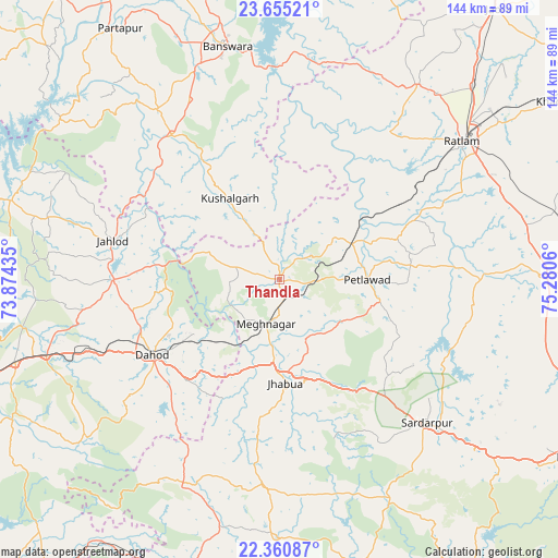
Thandla GPS coordinates[2]
23° 0' 34.524" North, 74° 34' 38.892" East
| Map corner | latitude | longitude |
|---|---|---|
| Upper-left | 23.65521°, | 73.87435° |
| Center: | 23.00959°, | 74.57747° |
| Lower-right: | 22.36087°, | 75.2806° |
| Map W x H: | 143.9×143.9 km | = 89.4×89.4mi |
| max Lat: | 34.9274° ⇑48.3% North |
| Thandla: | 23.00959° |
| min Lat: | ⇓51.7% South 8.09008° |
| min Long | Thandla | max Long |
| 68.82655° | 74.57747° | 96.81° |
| W 13.8%⇐ | ⇒86.2% E |
Elevation
Elevation of Thandla is 304 m = 997 ft, and this is 8.4 m = 28 ft above average elevation for this country.
| Max E: |
3681 m = 12077 ft | 32.7% |
| Thandla | 304 m 997 ft | |
| Avg. | 295.6 m = 970 ft | |
Min E: |
1 m = 3 ft | 67.3% |
See also: India elevation on elevation.city.
Geographical zone
Thandla is located in North Torrid zone (between Equator and Tropic of Cancer). Distance of this Northern Tropic circle is 47.5 km =29.5 mi to North.| Distance of | km | miles | from Thandla |
|---|---|---|---|
| North Pole | 7448.6 | 4628.3 | to North |
| Arctic Circle | 4842.7 | 3009.1 | to North |
| Tropic Cancer | 47.5 | 29.5 | to North |
| Equator | 2558.4 | 1589.7 | to South |


Nearby cities:
15 places around Thandla: (largest is in red/bold)
• Badnāwar
67.1 km =41.7 mi,  88°
88°
• Bamna
21.1 km =13.1 mi,  63°
63°
• Bhābhra
59.1 km =36.7 mi,  205°
205°
• Bāg
75.6 km =47 mi,  163°
163°
• Bānswāra
60.7 km =37.7 mi,  346°
346°
• Dohad
38 km =23.6 mi,  238°
238°
• Jhābua
26.9 km =16.7 mi,  177°
177°
• Jobat
66 km =41 mi, 180°
• Kushālgarh
24.7 km =15.3 mi,  328°
328°
• Namli
70.4 km =43.7 mi,  44°
44°
• Petlāwad
22.5 km =14 mi, 89°
• Ratlām
59.2 km =36.8 mi,  52°
52°
• Rājgarh
52.7 km =32.7 mi,  134°
134°
• Rānāpur
40.7 km =25.3 mi,  188°
188°
• Sailāna
61.5 km =38.2 mi, 35°
Sources, notices
• [Note1] Compared only with cities in India existing in our database
• [Src1] Map data: © OpenStreetMap contributors (CC-BY-SA)
• [Src2] Other city data from geonames.org with taken over terms of usage.
• [Src3] Geographical zone / Annual Mean Temperature by Robert A. Rohde @ Wikipedia
