Jhābua geodata
Jhābua (Madhya Pradesh) is a populated place; located in India in Asia/Kolkata (GMT+5.5) time zone. With population of 34,135 people, there are 1273 cities with bigger population in this country. Compared to other cities in India, 50.2% of cities are located further ↑North; 86% of cities are located further →East and 70.7% of cities have lower elevation than Jhābua. Note1


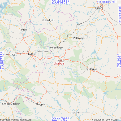
Jhābua GPS coordinates[2]
22° 46' 3.792" North, 74° 35' 27.132" East
| Map corner | latitude | longitude |
|---|---|---|
| Upper-left | 23.41451°, | 73.88775° |
| Center: | 22.76772°, | 74.59087° |
| Lower-right: | 22.11785°, | 75.294° |
| Map W x H: | 144.2×144.2 km | = 89.6×89.6mi |
| max Lat: | 34.9274° ⇑50.2% North |
| Jhābua: | 22.76772° |
| min Lat: | ⇓49.8% South 8.09008° |
| min Long | Jhābua | max Long |
| 68.82655° | 74.59087° | 96.81° |
| W 14%⇐ | ⇒86% E |
Elevation
Elevation of Jhābua is 334 m = 1096 ft, and this is 38.4 m = 126 ft above average elevation for this country.
| Max E: |
3681 m = 12077 ft | 29.3% |
| Jhābua | 334 m 1096 ft | |
| Avg. | 295.6 m = 970 ft | |
Min E: |
1 m = 3 ft | 70.7% |
See also: India elevation on elevation.city.
Geographical zone
Jhābua is located in North Torrid zone (between Equator and Tropic of Cancer). Distance of this Northern Tropic circle is 74.4 km =46.2 mi to North.| Distance of | km | miles | from Jhābua |
|---|---|---|---|
| North Pole | 7475.5 | 4645.1 | to North |
| Arctic Circle | 4869.6 | 3025.8 | to North |
| Tropic Cancer | 74.4 | 46.2 | to North |
| Equator | 2531.5 | 1573 | to South |


Nearby cities:
15 places around Jhābua: (largest is in red/bold)
• Badnāwar
71.6 km =44.5 mi,  66°
66°
• Bamna
40.3 km =25 mi,  25°
25°
• Bhābhra
37.7 km =23.4 mi,  225°
225°
• Bāg
49.8 km =30.9 mi,  155°
155°
• Devgadh Bāriya
70.3 km =43.7 mi,  264°
264°
• Dhār
75.1 km =46.7 mi,  104°
104°
• Dohad
34.7 km =21.6 mi,  282°
282°
• Jobat
39.2 km =24.4 mi,  183°
183°
• Kukshi
64.7 km =40.2 mi, 164°
• Kushālgarh
50.1 km =31.1 mi,  343°
343°
• Petlāwad
34.4 km =21.4 mi,  38°
38°
• Rajpur
56.9 km =35.4 mi,  205°
205°
• Rājgarh
37.6 km =23.4 mi,  105°
105°
• Rānāpur
15.2 km =9.4 mi, 208°
• Thandla
26.9 km =16.7 mi,  357°
357°
Sources, notices
• [Note1] Compared only with cities in India existing in our database
• [Src1] Map data: © OpenStreetMap contributors (CC-BY-SA)
• [Src2] Other city data from geonames.org with taken over terms of usage.
• [Src3] Geographical zone / Annual Mean Temperature by Robert A. Rohde @ Wikipedia
