Kushālgarh geodata
Kushālgarh (Rajasthan) is a populated place; located in India in Asia/Kolkata (GMT+5.5) time zone. With population of 10,349 people, there are 2907 cities with bigger population in this country. Compared to other cities in India, 52.9% of cities are located further ↓South; 87.2% of cities are located further →East and 66% of cities have lower elevation than Kushālgarh. Note1


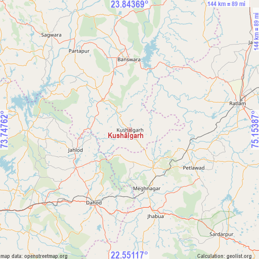
Kushālgarh GPS coordinates[2]
23° 11' 56.364" North, 74° 27' 2.664" East
| Map corner | latitude | longitude |
|---|---|---|
| Upper-left | 23.84369°, | 73.74762° |
| Center: | 23.19899°, | 74.45074° |
| Lower-right: | 22.55117°, | 75.15387° |
| Map W x H: | 143.7×143.7 km | = 89.3×89.3mi |
| max Lat: | 34.9274° ⇑47.1% North |
| Kushālgarh: | 23.19899° |
| min Lat: | ⇓52.9% South 8.09008° |
| min Long | Kushālgarh | max Long |
| 68.82655° | 74.45074° | 96.81° |
| W 12.8%⇐ | ⇒87.2% E |
Elevation
Elevation of Kushālgarh is 293 m = 961 ft, and this is 2.6 m = 9 ft below average elevation for this country.
| Max E: |
3681 m = 12077 ft | 34% |
| Avg. | 295.6 m = 970 ft | |
| Kushālgarh | 293 m = 961 ft | |
Min E: |
1 m = 3 ft | 66% |
See also: India elevation on elevation.city.
Geographical zone
Kushālgarh is located in North Torrid zone (between Equator and Tropic of Cancer). Distance of this Northern Tropic circle is 26.4 km =16.4 mi to North.| Distance of | km | miles | from Kushālgarh |
|---|---|---|---|
| North Pole | 7427.6 | 4615.3 | to North |
| Arctic Circle | 4821.7 | 2996.1 | to North |
| Tropic Cancer | 26.4 | 16.4 | to North |
| Equator | 2579.5 | 1602.8 | to South |


Nearby cities:
15 places around Kushālgarh: (largest is in red/bold)
• Bamna
33.8 km =21 mi,  110°
110°
• Bhābhra
75.4 km =46.9 mi,  189°
189°
• Bānswāra
38 km =23.6 mi,  358°
358°
• Dohad
45.2 km =28.1 mi,  205°
205°
• Galiākot
56.6 km =35.2 mi,  309°
309°
• Jhābua
50.1 km =31.1 mi,  163°
163°
• Morwa
70.6 km =43.9 mi,  242°
242°
• Namli
68.7 km =42.7 mi,  64°
64°
• Partāpur
52.1 km =32.4 mi,  327°
327°
• Petlāwad
41.2 km =25.6 mi,  120°
120°
• Ratlām
62 km =38.5 mi,  76°
76°
• Rājgarh
76.9 km =47.8 mi,  138°
138°
• Rānāpur
61.8 km =38.4 mi,  173°
173°
• Sailāna
56.4 km =35 mi, 58°
• Thandla
24.7 km =15.3 mi,  148°
148°
Sources, notices
• [Note1] Compared only with cities in India existing in our database
• [Src1] Map data: © OpenStreetMap contributors (CC-BY-SA)
• [Src2] Other city data from geonames.org with taken over terms of usage.
• [Src3] Geographical zone / Annual Mean Temperature by Robert A. Rohde @ Wikipedia
