Nāsriganj geodata
Nāsriganj (Bihar) is a populated place; located in India in Asia/Kolkata (GMT+5.5) time zone. With population of 23,286 people, there are 1818 cities with bigger population in this country. Compared to other cities in India, 63.8% of cities are located further ↓South; 82.6% of cities are located further ←West and 68.1% of cities have higher elevation than Nāsriganj. Note1


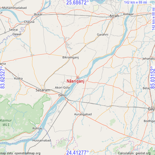
Nāsriganj GPS coordinates[2]
25° 3' 5.04" North, 84° 19' 42.204" East
| Map corner | latitude | longitude |
|---|---|---|
| Upper-left | 25.68672°, | 83.62527° |
| Center: | 25.0514°, | 84.32839° |
| Lower-right: | 24.41277°, | 85.03152° |
| Map W x H: | 141.6×141.7 km | = 88×88mi |
| max Lat: | 34.9274° ⇑36.2% North |
| Nāsriganj: | 25.0514° |
| min Lat: | ⇓63.8% South 8.09008° |
| min Long | Nāsriganj | max Long |
| 68.82655° | 84.32839° | 96.81° |
| W 82.6%⇐ | ⇒17.4% E |
Elevation
Elevation of Nāsriganj is 102 m = 335 ft, and this is 193.6 m = 635 ft below average elevation for this country.
| Max E: |
3681 m = 12077 ft | 68.1% |
| Avg. | 295.6 m = 970 ft | |
| Nāsriganj | 102 m = 335 ft | |
Min E: |
1 m = 3 ft | 31.9% |
See also: India elevation on elevation.city.
Geographical zone
Nāsriganj is located in North temperate zone (between Tropic of Cancer and the Arctic Circle). Distance of this Northern Tropic circle is 179.5 km =111.5 mi to South.| Distance of | km | miles | from Nāsriganj |
|---|---|---|---|
| North Pole | 7221.6 | 4487.3 | to North |
| Arctic Circle | 4615.7 | 2868.1 | to North |
| Tropic Cancer | 179.5 | 111.5 | to South |
| Equator | 2785.5 | 1730.8 | to South |


Nearby cities:
15 places around Nāsriganj: (largest is in red/bold)
• Arrah
65.5 km =40.7 mi,  30°
30°
• Aurangābād
33.6 km =20.9 mi,  172°
172°
• Bikramganj
19.2 km =11.9 mi,  337°
337°
• Buxar
68 km =42.3 mi,  329°
329°
• Daudnagar
7.5 km =4.7 mi,  104°
104°
• Dehri
22.2 km =13.8 mi,  221°
221°
• Dumraon
58.5 km =36.4 mi, 342°
• Husainābād
66.9 km =41.6 mi,  209°
209°
• Jagdīspur
47.2 km =29.3 mi,  11°
11°
• Koāth
31.3 km =19.4 mi,  347°
347°
• Nabīnagar
53.5 km =33.2 mi,  202°
202°
• Piro
32.1 km =19.9 mi, 13°
• Rafiganj
40.4 km =25.1 mi,  130°
130°
• Shāhpur
61.8 km =38.4 mi, 7°
• Tekāri
53.2 km =33.1 mi, 103°
Sources, notices
• [Note1] Compared only with cities in India existing in our database
• [Src1] Map data: © OpenStreetMap contributors (CC-BY-SA)
• [Src2] Other city data from geonames.org with taken over terms of usage.
• [Src3] Geographical zone / Annual Mean Temperature by Robert A. Rohde @ Wikipedia
