Rafiganj geodata
Rafiganj (Bihar) is a populated place; located in India in Asia/Kolkata (GMT+5.5) time zone. With population of 26,228 people, there are 1625 cities with bigger population in this country. Compared to other cities in India, 62.5% of cities are located further ↓South; 83.4% of cities are located further ←West and 67.2% of cities have higher elevation than Rafiganj. Note1


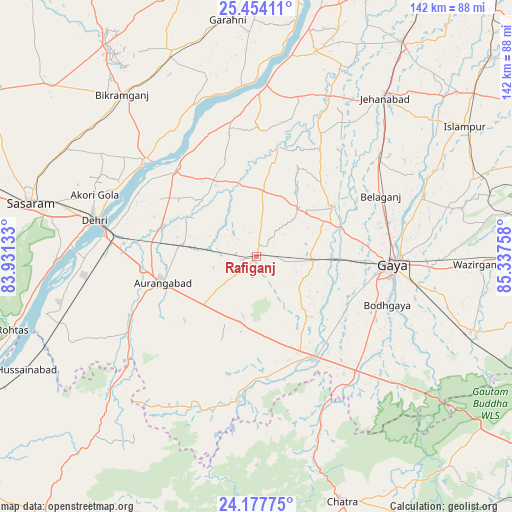
Rafiganj GPS coordinates[2]
24° 49' 3.252" North, 84° 38' 4.02" East
| Map corner | latitude | longitude |
|---|---|---|
| Upper-left | 25.45411°, | 83.93133° |
| Center: | 24.81757°, | 84.63445° |
| Lower-right: | 24.17775°, | 85.33758° |
| Map W x H: | 141.9×141.9 km | = 88.2×88.2mi |
| max Lat: | 34.9274° ⇑37.5% North |
| Rafiganj: | 24.81757° |
| min Lat: | ⇓62.5% South 8.09008° |
| min Long | Rafiganj | max Long |
| 68.82655° | 84.63445° | 96.81° |
| W 83.4%⇐ | ⇒16.6% E |
Elevation
Elevation of Rafiganj is 106 m = 348 ft, and this is 189.6 m = 622 ft below average elevation for this country.
| Max E: |
3681 m = 12077 ft | 67.2% |
| Avg. | 295.6 m = 970 ft | |
| Rafiganj | 106 m = 348 ft | |
Min E: |
1 m = 3 ft | 32.8% |
See also: India elevation on elevation.city.
Geographical zone
Rafiganj is located in North temperate zone (between Tropic of Cancer and the Arctic Circle). Distance of this Northern Tropic circle is 153.5 km =95.4 mi to South.| Distance of | km | miles | from Rafiganj |
|---|---|---|---|
| North Pole | 7247.6 | 4503.4 | to North |
| Arctic Circle | 4641.7 | 2884.2 | to North |
| Tropic Cancer | 153.5 | 95.4 | to South |
| Equator | 2759.5 | 1714.7 | to South |


Nearby cities:
15 places around Rafiganj: (largest is in red/bold)
• Aurangābād
27.3 km =17 mi,  254°
254°
• Bagaha
53.7 km =33.4 mi,  126°
126°
• Bikramganj
58.1 km =36.1 mi,  318°
318°
• Buddh Gaya
38 km =23.6 mi,  110°
110°
• Daudnagar
33.7 km =20.9 mi, 315°
• Dehri
46.6 km =29 mi,  281°
281°
• Gaya
37.4 km =23.2 mi,  93°
93°
• Islāmpur
67.9 km =42.2 mi,  58°
58°
• Jahānābād
56.6 km =35.2 mi,  38°
38°
• Koāth
68 km =42.3 mi,  326°
326°
• Nabīnagar
56.4 km =35 mi, 245°
• Nāsriganj
40.4 km =25.1 mi,  310°
310°
• Piro
61.7 km =38.3 mi,  337°
337°
• Sherghāti
32.8 km =20.4 mi,  151°
151°
• Tekāri
25.2 km =15.7 mi, 56°
Sources, notices
• [Note1] Compared only with cities in India existing in our database
• [Src1] Map data: © OpenStreetMap contributors (CC-BY-SA)
• [Src2] Other city data from geonames.org with taken over terms of usage.
• [Src3] Geographical zone / Annual Mean Temperature by Robert A. Rohde @ Wikipedia
