Aurangābād geodata
Aurangābād (Bihar) is a populated place; located in India in Asia/Kolkata (GMT+5.5) time zone. With population of 95,929 people, there are 463 cities with bigger population in this country. Compared to other cities in India, 62% of cities are located further ↓South; 82.8% of cities are located further ←West and 65.6% of cities have higher elevation than Aurangābād. Note1


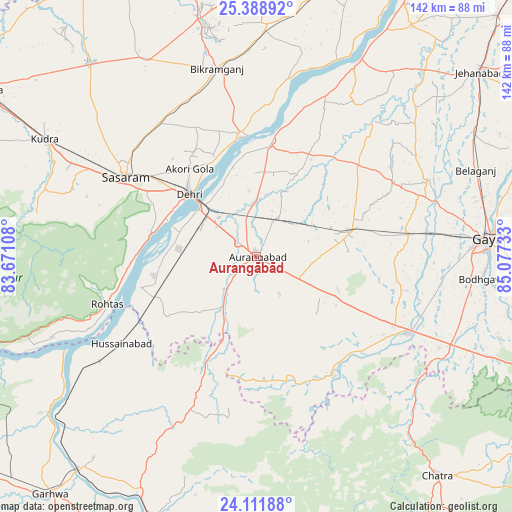
Aurangābād GPS coordinates[2]
24° 45' 7.344" North, 84° 22' 27.12" East
| Map corner | latitude | longitude |
|---|---|---|
| Upper-left | 25.38892°, | 83.67108° |
| Center: | 24.75204°, | 84.3742° |
| Lower-right: | 24.11188°, | 85.07733° |
| Map W x H: | 142×142 km | = 88.2×88.2mi |
| max Lat: | 34.9274° ⇑38% North |
| Aurangābād: | 24.75204° |
| min Lat: | ⇓62% South 8.09008° |
| min Long | Aurangābād | max Long |
| 68.82655° | 84.3742° | 96.81° |
| W 82.8%⇐ | ⇒17.2% E |
Elevation
Elevation of Aurangābād is 116 m = 381 ft, and this is 179.6 m = 589 ft below average elevation for this country.
| Max E: |
3681 m = 12077 ft | 65.6% |
| Avg. | 295.6 m = 970 ft | |
| Aurangābād | 116 m = 381 ft | |
Min E: |
1 m = 3 ft | 34.4% |
See also: Aurangābād elevation on elevation.city.
Geographical zone
Aurangābād is located in North temperate zone (between Tropic of Cancer and the Arctic Circle). Distance of this Northern Tropic circle is 146.2 km =90.8 mi to South.| Distance of | km | miles | from Aurangābād |
|---|---|---|---|
| North Pole | 7254.9 | 4508 | to North |
| Arctic Circle | 4649 | 2888.8 | to North |
| Tropic Cancer | 146.2 | 90.8 | to South |
| Equator | 2752.2 | 1710.1 | to South |


Nearby cities:
15 places around Aurangābād: (largest is in red/bold)
• Bagaha
73.6 km =45.7 mi,  109°
109°
• Bikramganj
52.4 km =32.6 mi,  346°
346°
• Buddh Gaya
62.2 km =38.6 mi,  95°
95°
• Chatrā
78.8 km =49 mi,  140°
140°
• Daudnagar
31.5 km =19.6 mi,  4°
4°
• Dehri
25.6 km =15.9 mi,  310°
310°
• Gaya
63.8 km =39.6 mi,  85°
85°
• Husainābād
45.3 km =28.1 mi,  236°
236°
• Koāth
64.9 km =40.3 mi, 349°
• Nabīnagar
29.8 km =18.5 mi, 237°
• Nāsriganj
33.6 km =20.9 mi, 352°
• Piro
64.6 km =40.1 mi, 2°
• Rafiganj
27.3 km =17 mi,  74°
74°
• Sherghāti
47.3 km =29.4 mi,  116°
116°
• Tekāri
51.8 km =32.2 mi, 65°
Sources, notices
• [Note1] Compared only with cities in India existing in our database
• [Src1] Map data: © OpenStreetMap contributors (CC-BY-SA)
• [Src2] Other city data from geonames.org with taken over terms of usage.
• [Src3] Geographical zone / Annual Mean Temperature by Robert A. Rohde @ Wikipedia
