Chandpura geodata
Chandpura (Madhya Pradesh) is a populated place; located in India in Asia/Kolkata (GMT+5.5) time zone. With population of 557 people, there are 3472 cities with bigger population in this country. Compared to other cities in India, 57.4% of cities are located further ↓South; 59.9% of cities are located further →East and 80.7% of cities have lower elevation than Chandpura. Note1


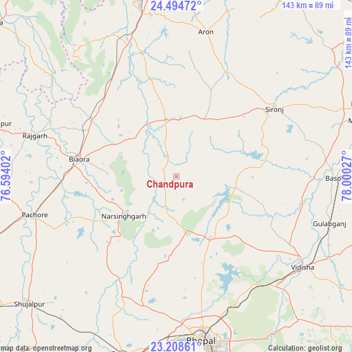
Chandpura GPS coordinates[2]
23° 51' 11.736" North, 77° 17' 49.704" East
| Map corner | latitude | longitude |
|---|---|---|
| Upper-left | 24.49472°, | 76.59402° |
| Center: | 23.85326°, | 77.29714° |
| Lower-right: | 23.20861°, | 78.00027° |
| Map W x H: | 143×143 km | = 88.9×88.9mi |
| max Lat: | 34.9274° ⇑42.6% North |
| Chandpura: | 23.85326° |
| min Lat: | ⇓57.4% South 8.09008° |
| min Long | Chandpura | max Long |
| 68.82655° | 77.29714° | 96.81° |
| W 40.1%⇐ | ⇒59.9% E |
Elevation
Elevation of Chandpura is 470 m = 1542 ft, and this is 174.4 m = 572 ft above average elevation for this country.
| Max E: |
3681 m = 12077 ft | 19.3% |
| Chandpura | 470 m 1542 ft | |
| Avg. | 295.6 m = 970 ft | |
Min E: |
1 m = 3 ft | 80.7% |
See also: India elevation on elevation.city.
Geographical zone
Chandpura is located in North temperate zone (between Tropic of Cancer and the Arctic Circle). Distance of this Northern Tropic circle is 46.3 km =28.8 mi to South.| Distance of | km | miles | from Chandpura |
|---|---|---|---|
| North Pole | 7354.8 | 4570.1 | to North |
| Arctic Circle | 4748.9 | 2950.8 | to North |
| Tropic Cancer | 46.3 | 28.8 | to South |
| Equator | 2652.2 | 1648 | to South |


Nearby cities:
15 places around Chandpura: (largest is in red/bold)
• Berasia
28.3 km =17.6 mi,  150°
150°
• Biaora
40 km =24.9 mi,  280°
280°
• Bāsoda
65 km =40.4 mi,  90°
90°
• Garha Brahman
6.4 km =4 mi,  74°
74°
• Khata Khedi
2.2 km =1.4 mi,  340°
340°
• Kumbhrāj
63.1 km =39.2 mi, 336°
• Leteri
25.6 km =15.9 mi,  26°
26°
• Narsinghgarh
26.3 km =16.3 mi,  232°
232°
• Patalpani
5.9 km =3.7 mi,  102°
102°
• Rājgarh
59.9 km =37.2 mi,  286°
286°
• Sironj
48.7 km =30.3 mi,  55°
55°
• Sānchi
60.6 km =37.7 mi,  132°
132°
• Talen
66 km =41 mi,  241°
241°
• Vidisha
63.7 km =39.6 mi,  124°
124°
• Āron
59.9 km =37.2 mi,  11°
11°
Sources, notices
• [Note1] Compared only with cities in India existing in our database
• [Src1] Map data: © OpenStreetMap contributors (CC-BY-SA)
• [Src2] Other city data from geonames.org with taken over terms of usage.
• [Src3] Geographical zone / Annual Mean Temperature by Robert A. Rohde @ Wikipedia
