Biaora geodata
Biaora (Madhya Pradesh) is a populated place; located in India in Asia/Kolkata (GMT+5.5) time zone. With population of 41,989 people, there are 1053 cities with bigger population in this country. Compared to other cities in India, 57.8% of cities are located further ↓South; 64.3% of cities are located further →East and 78.2% of cities have lower elevation than Biaora. Note1


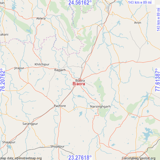
Biaora GPS coordinates[2]
23° 55' 13.8" North, 76° 54' 38.664" East
| Map corner | latitude | longitude |
|---|---|---|
| Upper-left | 24.56162°, | 76.20762° |
| Center: | 23.9205°, | 76.91074° |
| Lower-right: | 23.27618°, | 77.61387° |
| Map W x H: | 142.9×142.9 km | = 88.8×88.8mi |
| max Lat: | 34.9274° ⇑42.2% North |
| Biaora: | 23.9205° |
| min Lat: | ⇓57.8% South 8.09008° |
| min Long | Biaora | max Long |
| 68.82655° | 76.91074° | 96.81° |
| W 35.7%⇐ | ⇒64.3% E |
Elevation
Elevation of Biaora is 433 m = 1421 ft, and this is 137.4 m = 451 ft above average elevation for this country.
| Max E: |
3681 m = 12077 ft | 21.8% |
| Biaora | 433 m 1421 ft | |
| Avg. | 295.6 m = 970 ft | |
Min E: |
1 m = 3 ft | 78.2% |
See also: Biaora elevation on elevation.city.
Geographical zone
Biaora is located in North temperate zone (between Tropic of Cancer and the Arctic Circle). Distance of this Northern Tropic circle is 53.8 km =33.4 mi to South.| Distance of | km | miles | from Biaora |
|---|---|---|---|
| North Pole | 7347.4 | 4565.5 | to North |
| Arctic Circle | 4741.5 | 2946.2 | to North |
| Tropic Cancer | 53.8 | 33.4 | to South |
| Equator | 2659.7 | 1652.7 | to South |


Nearby cities:
15 places around Biaora: (largest is in red/bold)
• Berasia
62.2 km =38.6 mi,  121°
121°
• Chandpura
40 km =24.9 mi,  100°
100°
• Garha Brahman
45.8 km =28.5 mi, 97°
• Khata Khedi
38.9 km =24.2 mi, 97°
• Khilchipur
36.3 km =22.6 mi,  291°
291°
• Khujner
33.3 km =20.7 mi,  243°
243°
• Kumbhrāj
52.3 km =32.5 mi,  15°
15°
• Leteri
52.9 km =32.9 mi,  72°
72°
• Manohar Thāna
37.2 km =23.1 mi,  342°
342°
• Narsinghgarh
30.1 km =18.7 mi,  141°
141°
• Patalpani
45.9 km =28.5 mi, 101°
• Rājgarh
20.6 km =12.8 mi,  298°
298°
• Shujālpur
60.7 km =37.7 mi,  199°
199°
• Sārangpur
59.4 km =36.9 mi,  228°
228°
• Talen
43.2 km =26.8 mi,  205°
205°
Sources, notices
• [Note1] Compared only with cities in India existing in our database
• [Src1] Map data: © OpenStreetMap contributors (CC-BY-SA)
• [Src2] Other city data from geonames.org with taken over terms of usage.
• [Src3] Geographical zone / Annual Mean Temperature by Robert A. Rohde @ Wikipedia
