Khilchipur geodata
Khilchipur (Madhya Pradesh) is a populated place; located in India in Asia/Kolkata (GMT+5.5) time zone. With population of 16,411 people, there are 2334 cities with bigger population in this country. Compared to other cities in India, 58.3% of cities are located further ↓South; 67.5% of cities are located further →East and 75.6% of cities have lower elevation than Khilchipur. Note1


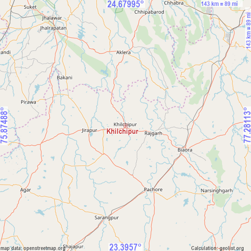
Khilchipur GPS coordinates[2]
24° 2' 21.948" North, 76° 34' 40.8" East
| Map corner | latitude | longitude |
|---|---|---|
| Upper-left | 24.67995°, | 75.87488° |
| Center: | 24.03943°, | 76.578° |
| Lower-right: | 23.3957°, | 77.28113° |
| Map W x H: | 142.8×142.8 km | = 88.7×88.7mi |
| max Lat: | 34.9274° ⇑41.7% North |
| Khilchipur: | 24.03943° |
| min Lat: | ⇓58.3% South 8.09008° |
| min Long | Khilchipur | max Long |
| 68.82655° | 76.578° | 96.81° |
| W 32.5%⇐ | ⇒67.5% E |
Elevation
Elevation of Khilchipur is 394 m = 1293 ft, and this is 98.4 m = 323 ft above average elevation for this country.
| Max E: |
3681 m = 12077 ft | 24.4% |
| Khilchipur | 394 m 1293 ft | |
| Avg. | 295.6 m = 970 ft | |
Min E: |
1 m = 3 ft | 75.6% |
See also: India elevation on elevation.city.
Geographical zone
Khilchipur is located in North temperate zone (between Tropic of Cancer and the Arctic Circle). Distance of this Northern Tropic circle is 67 km =41.6 mi to South.| Distance of | km | miles | from Khilchipur |
|---|---|---|---|
| North Pole | 7334.1 | 4557.2 | to North |
| Arctic Circle | 4728.2 | 2938 | to North |
| Tropic Cancer | 67 | 41.6 | to South |
| Equator | 2672.9 | 1660.9 | to South |


Nearby cities:
15 places around Khilchipur: (largest is in red/bold)
• Agar
67.8 km =42.1 mi,  237°
237°
• Aklera
41.5 km =25.8 mi,  358°
358°
• Bakāni
44.1 km =27.4 mi,  308°
308°
• Biaora
36.3 km =22.6 mi,  111°
111°
• Jhālrapātan
69.4 km =43.1 mi,  323°
323°
• Khujner
28.5 km =17.7 mi,  171°
171°
• Kumbhrāj
60.5 km =37.6 mi,  52°
52°
• Manohar Thāna
31.8 km =19.8 mi, 45°
• Māchalpur
28.3 km =17.6 mi,  290°
290°
• Narsinghgarh
64.1 km =39.8 mi,  125°
125°
• Pirāwa
57.4 km =35.7 mi,  282°
282°
• Rājgarh
16.1 km =10 mi,  102°
102°
• Susner
50.8 km =31.6 mi,  258°
258°
• Sārangpur
53.7 km =33.4 mi,  191°
191°
• Talen
54.4 km =33.8 mi,  163°
163°
Sources, notices
• [Note1] Compared only with cities in India existing in our database
• [Src1] Map data: © OpenStreetMap contributors (CC-BY-SA)
• [Src2] Other city data from geonames.org with taken over terms of usage.
• [Src3] Geographical zone / Annual Mean Temperature by Robert A. Rohde @ Wikipedia
