Supaul geodata
Supaul (Bihar) is a populated place; located in India in Asia/Kolkata (GMT+5.5) time zone. With population of 60,020 people, there are 731 cities with bigger population in this country. Compared to other cities in India, 71.3% of cities are located further ↓South; 88.5% of cities are located further ←West and 77.7% of cities have higher elevation than Supaul. Note1


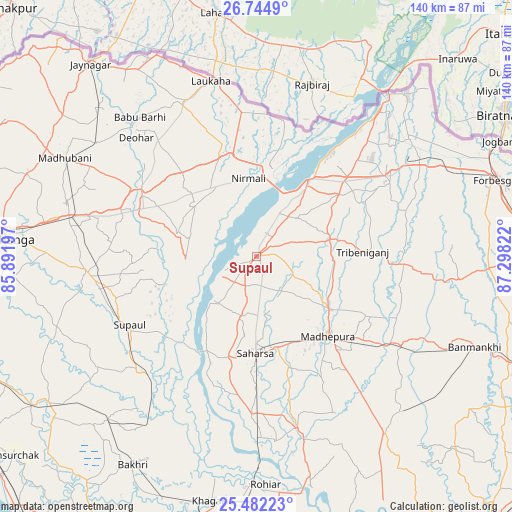
Supaul GPS coordinates[2]
26° 6' 54.972" North, 86° 35' 42.324" East
| Map corner | latitude | longitude |
|---|---|---|
| Upper-left | 26.7449°, | 85.89197° |
| Center: | 26.11527°, | 86.59509° |
| Lower-right: | 25.48223°, | 87.29822° |
| Map W x H: | 140.4×140.4 km | = 87.2×87.2mi |
| max Lat: | 34.9274° ⇑28.7% North |
| Supaul: | 26.11527° |
| min Lat: | ⇓71.3% South 8.09008° |
| min Long | Supaul | max Long |
| 68.82655° | 86.59509° | 96.81° |
| W 88.5%⇐ | ⇒11.5% E |
Elevation
Elevation of Supaul is 56 m = 184 ft, and this is 239.6 m = 786 ft below average elevation for this country.
| Max E: |
3681 m = 12077 ft | 77.7% |
| Avg. | 295.6 m = 970 ft | |
| Supaul | 56 m = 184 ft | |
Min E: |
1 m = 3 ft | 22.3% |
See also: Supaul elevation on elevation.city.
Geographical zone
Supaul is located in North temperate zone (between Tropic of Cancer and the Arctic Circle). Distance of this Northern Tropic circle is 297.8 km =185 mi to South.| Distance of | km | miles | from Supaul |
|---|---|---|---|
| North Pole | 7103.3 | 4413.8 | to North |
| Arctic Circle | 4497.4 | 2794.6 | to North |
| Tropic Cancer | 297.8 | 185 | to South |
| Equator | 2903.7 | 1804.3 | to South |


Nearby cities:
15 places around Supaul: (largest is in red/bold)
• Bangaon
28.8 km =17.9 mi,  196°
196°
• Banmankhi
65 km =40.4 mi,  112°
112°
• Bhagirathpur
55.7 km =34.6 mi,  287°
287°
• Bhawanipur
57.2 km =35.5 mi,  48°
48°
• Bihārīganj
57.8 km =35.9 mi,  137°
137°
• Bīrpur
60.3 km =37.5 mi,  43°
43°
• Chhātāpur
42.5 km =26.4 mi,  74°
74°
• Jhanjhārpur
35.6 km =22.1 mi,  297°
297°
• Khagaria
69.4 km =43.1 mi,  190°
190°
• Madhipura
29.2 km =18.1 mi, 137°
• Madhubani
58.5 km =36.4 mi, 296°
• Murlīganj
46.8 km =29.1 mi,  121°
121°
• Nirmāli
22.1 km =13.7 mi,  357°
357°
• Rusera
69.7 km =43.3 mi,  234°
234°
• Saharsa
26.7 km =16.6 mi,  179°
179°
Sources, notices
• [Note1] Compared only with cities in India existing in our database
• [Src1] Map data: © OpenStreetMap contributors (CC-BY-SA)
• [Src2] Other city data from geonames.org with taken over terms of usage.
• [Src3] Geographical zone / Annual Mean Temperature by Robert A. Rohde @ Wikipedia
