Madhubani geodata
Madhubani (Bihar) is a populated place; located in India in Asia/Kolkata (GMT+5.5) time zone. With population of 71,582 people, there are 610 cities with bigger population in this country. Compared to other cities in India, 73.5% of cities are located further ↓South; 87.2% of cities are located further ←West and 76.5% of cities have higher elevation than Madhubani. Note1


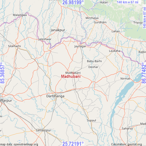
Madhubani GPS coordinates[2]
26° 21' 13.212" North, 86° 4' 18.084" East
| Map corner | latitude | longitude |
|---|---|---|
| Upper-left | 26.98199°, | 85.36857° |
| Center: | 26.35367°, | 86.07169° |
| Lower-right: | 25.72191°, | 86.77482° |
| Map W x H: | 140.1×140.1 km | = 87.1×87.1mi |
| max Lat: | 34.9274° ⇑26.5% North |
| Madhubani: | 26.35367° |
| min Lat: | ⇓73.5% South 8.09008° |
| min Long | Madhubani | max Long |
| 68.82655° | 86.07169° | 96.81° |
| W 87.2%⇐ | ⇒12.8% E |
Elevation
Elevation of Madhubani is 61 m = 200 ft, and this is 234.6 m = 770 ft below average elevation for this country.
| Max E: |
3681 m = 12077 ft | 76.5% |
| Avg. | 295.6 m = 970 ft | |
| Madhubani | 61 m = 200 ft | |
Min E: |
1 m = 3 ft | 23.5% |
See also: Madhubani elevation on elevation.city.
Geographical zone
Madhubani is located in North temperate zone (between Tropic of Cancer and the Arctic Circle). Distance of this Northern Tropic circle is 324.3 km =201.5 mi to South.| Distance of | km | miles | from Madhubani |
|---|---|---|---|
| North Pole | 7076.8 | 4397.3 | to North |
| Arctic Circle | 4470.9 | 2778.1 | to North |
| Tropic Cancer | 324.3 | 201.5 | to South |
| Equator | 2930.3 | 1820.8 | to South |


Nearby cities:
15 places around Madhubani: (largest is in red/bold)
• Bangaon
69.7 km =43.3 mi,  140°
140°
• Belsand
67.6 km =42 mi,  278°
278°
• Bhagirathpur
9.4 km =5.8 mi,  185°
185°
• Darbhanga
28.4 km =17.6 mi,  217°
217°
• Dumra
59.8 km =37.2 mi,  293°
293°
• Jaynagar
27.1 km =16.8 mi,  14°
14°
• Jhanjhārpur
23 km =14.3 mi,  115°
115°
• Muzaffarpur
72.6 km =45.1 mi,  249°
249°
• Nirmāli
51.4 km =31.9 mi,  94°
94°
• Pupri
38.9 km =24.2 mi, 289°
• Rusera
66.9 km =41.6 mi,  183°
183°
• Saharsa
74.7 km =46.4 mi, 135°
• Samāstipur
61.9 km =38.5 mi,  208°
208°
• Supaul
58.5 km =36.4 mi, 116°
• Sītāmarhi
63.7 km =39.6 mi, 294°
Sources, notices
• [Note1] Compared only with cities in India existing in our database
• [Src1] Map data: © OpenStreetMap contributors (CC-BY-SA)
• [Src2] Other city data from geonames.org with taken over terms of usage.
• [Src3] Geographical zone / Annual Mean Temperature by Robert A. Rohde @ Wikipedia
