Jhanjhārpur geodata
Jhanjhārpur (Bihar) is a populated place; located in India in Asia/Kolkata (GMT+5.5) time zone. With population of 31,283 people, there are 1386 cities with bigger population in this country. Compared to other cities in India, 72.5% of cities are located further ↓South; 87.6% of cities are located further ←West and 77.7% of cities have higher elevation than Jhanjhārpur. Note1


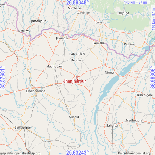
Jhanjhārpur GPS coordinates[2]
26° 15' 52.812" North, 86° 16' 47.748" East
| Map corner | latitude | longitude |
|---|---|---|
| Upper-left | 26.89348°, | 85.57681° |
| Center: | 26.26467°, | 86.27993° |
| Lower-right: | 25.63243°, | 86.98306° |
| Map W x H: | 140.2×140.2 km | = 87.1×87.1mi |
| max Lat: | 34.9274° ⇑27.5% North |
| Jhanjhārpur: | 26.26467° |
| min Lat: | ⇓72.5% South 8.09008° |
| min Long | Jhanjhārpur | max Long |
| 68.82655° | 86.27993° | 96.81° |
| W 87.6%⇐ | ⇒12.4% E |
Elevation
Elevation of Jhanjhārpur is 56 m = 184 ft, and this is 239.6 m = 786 ft below average elevation for this country.
| Max E: |
3681 m = 12077 ft | 77.7% |
| Avg. | 295.6 m = 970 ft | |
| Jhanjhārpur | 56 m = 184 ft | |
Min E: |
1 m = 3 ft | 22.3% |
See also: India elevation on elevation.city.
Geographical zone
Jhanjhārpur is located in North temperate zone (between Tropic of Cancer and the Arctic Circle). Distance of this Northern Tropic circle is 314.4 km =195.4 mi to South.| Distance of | km | miles | from Jhanjhārpur |
|---|---|---|---|
| North Pole | 7086.7 | 4403.5 | to North |
| Arctic Circle | 4480.8 | 2784.2 | to North |
| Tropic Cancer | 314.4 | 195.4 | to South |
| Equator | 2920.4 | 1814.7 | to South |


Nearby cities:
15 places around Jhanjhārpur: (largest is in red/bold)
• Bangaon
49.9 km =31 mi,  152°
152°
• Bhagirathpur
21.6 km =13.4 mi,  271°
271°
• Bhawanipur
77.4 km =48.1 mi,  74°
74°
• Bīrpur
77.8 km =48.3 mi, 69°
• Chhātāpur
72.5 km =45 mi,  93°
93°
• Darbhanga
40.2 km =25 mi,  251°
251°
• Jaynagar
38.9 km =24.2 mi,  338°
338°
• Madhipura
63.9 km =39.7 mi,  126°
126°
• Madhubani
23 km =14.3 mi,  295°
295°
• Nirmāli
30.9 km =19.2 mi,  79°
79°
• Pupri
61.9 km =38.5 mi,  291°
291°
• Rusera
62.2 km =38.6 mi,  204°
204°
• Saharsa
53.6 km =33.3 mi,  143°
143°
• Samāstipur
67.1 km =41.7 mi,  228°
228°
• Supaul
35.6 km =22.1 mi,  117°
117°
Sources, notices
• [Note1] Compared only with cities in India existing in our database
• [Src1] Map data: © OpenStreetMap contributors (CC-BY-SA)
• [Src2] Other city data from geonames.org with taken over terms of usage.
• [Src3] Geographical zone / Annual Mean Temperature by Robert A. Rohde @ Wikipedia
