Nirmāli geodata
Nirmāli (Bihar) is a populated place; located in India in Asia/Kolkata (GMT+5.5) time zone. With population of 17,102 people, there are 2275 cities with bigger population in this country. Compared to other cities in India, 73.1% of cities are located further ↓South; 88.4% of cities are located further ←West and 77.2% of cities have higher elevation than Nirmāli. Note1


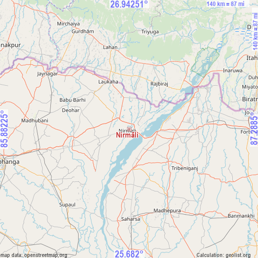
Nirmāli GPS coordinates[2]
26° 18' 50.292" North, 86° 35' 7.332" East
| Map corner | latitude | longitude |
|---|---|---|
| Upper-left | 26.94251°, | 85.88225° |
| Center: | 26.31397°, | 86.58537° |
| Lower-right: | 25.682°, | 87.2885° |
| Map W x H: | 140.2×140.2 km | = 87.1×87.1mi |
| max Lat: | 34.9274° ⇑26.9% North |
| Nirmāli: | 26.31397° |
| min Lat: | ⇓73.1% South 8.09008° |
| min Long | Nirmāli | max Long |
| 68.82655° | 86.58537° | 96.81° |
| W 88.4%⇐ | ⇒11.6% E |
Elevation
Elevation of Nirmāli is 58 m = 190 ft, and this is 237.6 m = 780 ft below average elevation for this country.
| Max E: |
3681 m = 12077 ft | 77.2% |
| Avg. | 295.6 m = 970 ft | |
| Nirmāli | 58 m = 190 ft | |
Min E: |
1 m = 3 ft | 22.8% |
See also: India elevation on elevation.city.
Geographical zone
Nirmāli is located in North temperate zone (between Tropic of Cancer and the Arctic Circle). Distance of this Northern Tropic circle is 319.9 km =198.8 mi to South.| Distance of | km | miles | from Nirmāli |
|---|---|---|---|
| North Pole | 7081.2 | 4400.1 | to North |
| Arctic Circle | 4475.3 | 2780.8 | to North |
| Tropic Cancer | 319.9 | 198.8 | to South |
| Equator | 2925.8 | 1818 | to South |


Nearby cities:
15 places around Nirmāli: (largest is in red/bold)
• Bangaon
50.2 km =31.2 mi,  188°
188°
• Bhagirathpur
52.3 km =32.5 mi,  264°
264°
• Bhawanipur
46.7 km =29 mi,  70°
70°
• Bīrpur
47.7 km =29.6 mi,  63°
63°
• Chhātāpur
43.1 km =26.8 mi,  104°
104°
• Forbesganj
67.8 km =42.1 mi,  91°
91°
• Jaynagar
54.1 km =33.6 mi,  304°
304°
• Jhanjhārpur
30.9 km =19.2 mi, 259°
• Jogbani
68.4 km =42.5 mi,  82°
82°
• Madhipura
48.3 km =30 mi,  154°
154°
• Madhubani
51.4 km =31.9 mi,  274°
274°
• Murlīganj
61.9 km =38.5 mi,  138°
138°
• Saharsa
48.8 km =30.3 mi,  178°
178°
• Shahbazpur
70.1 km =43.6 mi, 90°
• Supaul
22.1 km =13.7 mi, 177°
Sources, notices
• [Note1] Compared only with cities in India existing in our database
• [Src1] Map data: © OpenStreetMap contributors (CC-BY-SA)
• [Src2] Other city data from geonames.org with taken over terms of usage.
• [Src3] Geographical zone / Annual Mean Temperature by Robert A. Rohde @ Wikipedia
