Banmankhi geodata
Banmankhi (Bihar) is a populated place; located in India in Asia/Kolkata (GMT+5.5) time zone. With population of 26,806 people, there are 1592 cities with bigger population in this country. Compared to other cities in India, 69.6% of cities are located further ↓South; 89.6% of cities are located further ←West and 79.7% of cities have higher elevation than Banmankhi. Note1


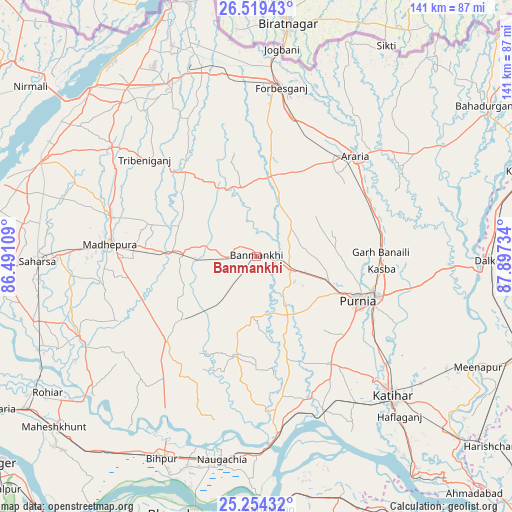
Banmankhi GPS coordinates[2]
25° 53' 18.852" North, 87° 11' 39.156" East
| Map corner | latitude | longitude |
|---|---|---|
| Upper-left | 26.51943°, | 86.49109° |
| Center: | 25.88857°, | 87.19421° |
| Lower-right: | 25.25432°, | 87.89734° |
| Map W x H: | 140.7×140.7 km | = 87.4×87.4mi |
| max Lat: | 34.9274° ⇑30.4% North |
| Banmankhi: | 25.88857° |
| min Lat: | ⇓69.6% South 8.09008° |
| min Long | Banmankhi | max Long |
| 68.82655° | 87.19421° | 96.81° |
| W 89.6%⇐ | ⇒10.4% E |
Elevation
Elevation of Banmankhi is 49 m = 161 ft, and this is 246.6 m = 809 ft below average elevation for this country.
| Max E: |
3681 m = 12077 ft | 79.7% |
| Avg. | 295.6 m = 970 ft | |
| Banmankhi | 49 m = 161 ft | |
Min E: |
1 m = 3 ft | 20.3% |
See also: India elevation on elevation.city.
Geographical zone
Banmankhi is located in North temperate zone (between Tropic of Cancer and the Arctic Circle). Distance of this Northern Tropic circle is 272.6 km =169.4 mi to South.| Distance of | km | miles | from Banmankhi |
|---|---|---|---|
| North Pole | 7128.5 | 4429.4 | to North |
| Arctic Circle | 4522.6 | 2810.2 | to North |
| Tropic Cancer | 272.6 | 169.4 | to South |
| Equator | 2878.5 | 1788.6 | to South |


Nearby cities:
15 places around Banmankhi: (largest is in red/bold)
• Arāria
43.1 km =26.8 mi,  47°
47°
• Baisi
55.2 km =34.3 mi,  92°
92°
• Bihārīganj
26.8 km =16.7 mi,  230°
230°
• Chhātāpur
41.4 km =25.7 mi,  332°
332°
• Dalkola
64.6 km =40.1 mi, 91°
• Forbesganj
46.6 km =29 mi,  8°
8°
• Jogbani
57.2 km =35.5 mi, 7°
• Kasba
34.6 km =21.5 mi,  95°
95°
• Katihar
54.2 km =33.7 mi,  135°
135°
• Madhipura
40.3 km =25 mi,  275°
275°
• Murlīganj
19.9 km =12.4 mi,  272°
272°
• Naugachhia
56.5 km =35.1 mi,  189°
189°
• Purnia
30.6 km =19 mi,  113°
113°
• Saharsa
59.9 km =37.2 mi, 268°
• Shahbazpur
47.3 km =29.4 mi, 11°
Sources, notices
• [Note1] Compared only with cities in India existing in our database
• [Src1] Map data: © OpenStreetMap contributors (CC-BY-SA)
• [Src2] Other city data from geonames.org with taken over terms of usage.
• [Src3] Geographical zone / Annual Mean Temperature by Robert A. Rohde @ Wikipedia
