Pathalgaon geodata
Pathalgaon (Chhattisgarh) is a populated place; located in India in Asia/Kolkata (GMT+5.5) time zone. With population of 15,394 people, there are 2424 cities with bigger population in this country. Compared to other cities in India, 52.6% of cities are located further ↑North; 80.7% of cities are located further ←West and 86.8% of cities have lower elevation than Pathalgaon. Note1


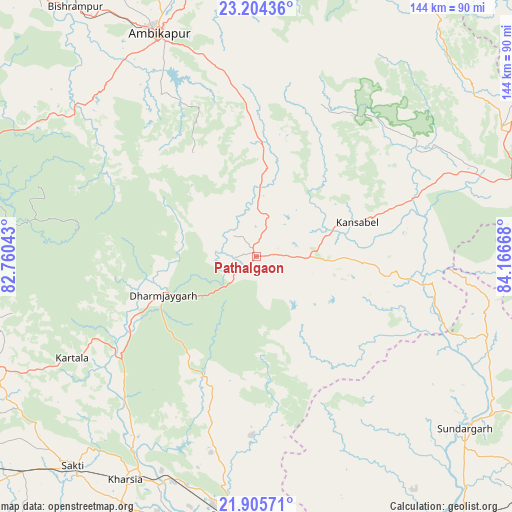
Pathalgaon GPS coordinates[2]
22° 33' 23.616" North, 83° 27' 48.78" East
| Map corner | latitude | longitude |
|---|---|---|
| Upper-left | 23.20436°, | 82.76043° |
| Center: | 22.55656°, | 83.46355° |
| Lower-right: | 21.90571°, | 84.16668° |
| Map W x H: | 144.4×144.4 km | = 89.7×89.7mi |
| max Lat: | 34.9274° ⇑52.6% North |
| Pathalgaon: | 22.55656° |
| min Lat: | ⇓47.4% South 8.09008° |
| min Long | Pathalgaon | max Long |
| 68.82655° | 83.46355° | 96.81° |
| W 80.7%⇐ | ⇒19.3% E |
Elevation
Elevation of Pathalgaon is 573 m = 1880 ft, and this is 277.4 m = 910 ft above average elevation for this country.
| Max E: |
3681 m = 12077 ft | 13.2% |
| Pathalgaon | 573 m 1880 ft | |
| Avg. | 295.6 m = 970 ft | |
Min E: |
1 m = 3 ft | 86.8% |
See also: India elevation on elevation.city.
Geographical zone
Pathalgaon is located in North Torrid zone (between Equator and Tropic of Cancer). Distance of this Northern Tropic circle is 97.9 km =60.8 mi to North.| Distance of | km | miles | from Pathalgaon |
|---|---|---|---|
| North Pole | 7499 | 4659.7 | to North |
| Arctic Circle | 4893.1 | 3040.4 | to North |
| Tropic Cancer | 97.9 | 60.8 | to North |
| Equator | 2508.1 | 1558.5 | to South |


Nearby cities:
15 places around Pathalgaon: (largest is in red/bold)
• Ambikāpur
68.3 km =42.4 mi,  336°
336°
• Brājarājnagar
94.6 km =58.8 mi,  150°
150°
• Chāmpa
102.5 km =63.7 mi,  235°
235°
• Gharghoda
44 km =27.3 mi,  195°
195°
• Jashpurnagar
78.4 km =48.7 mi,  61°
61°
• Jharsuguda
96 km =59.7 mi,  144°
144°
• Jānjgīr
109.6 km =68.1 mi, 236°
• Katghora
94.8 km =58.9 mi,  266°
266°
• Kharsia
73.1 km =45.4 mi,  210°
210°
• Korba
82.2 km =51.1 mi,  253°
253°
• Raigarh
73.6 km =45.7 mi,  185°
185°
• Saktī
78.4 km =48.7 mi,  221°
221°
• Simdega
106.8 km =66.4 mi,  86°
86°
• Sundargarh
76.3 km =47.4 mi,  129°
129°
• Surajpur
95.1 km =59.1 mi,  320°
320°
Sources, notices
• [Note1] Compared only with cities in India existing in our database
• [Src1] Map data: © OpenStreetMap contributors (CC-BY-SA)
• [Src2] Other city data from geonames.org with taken over terms of usage.
• [Src3] Geographical zone / Annual Mean Temperature by Robert A. Rohde @ Wikipedia
